Muria Strait Economy (Disaster).
Floods in Semarang and its surroundings in Central Java have given rise to stories about the Muria Strait again. Will it come back?
This article has been translated using AI. See Original .
About AI Translated Article
Please note that this article was automatically translated using Microsoft Azure AI, Open AI, and Google Translation AI. We cannot ensure that the entire content is translated accurately. If you spot any errors or inconsistencies, contact us at hotline@kompas.id, and we'll make every effort to address them. Thank you for your understanding.
The access to the Pantura route is once again flooded and impassable by vehicles in the Karanganyar sub-district, Demak Regency, Central Java on Sunday (17/3/2024). The flood was caused by the overflow of the Wulan River embankment and several rivers in the area.
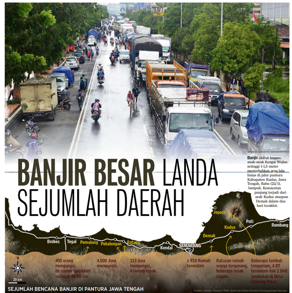
Floods in Semarang, Demak, Kudus, Pati, Grobogan and Jepara in Central Java are widely discussed. One of the hot topics that has made these economic and religious support cities a topic of conversation is the potential for the re-emergence of the Muria Strait.
In February 2024, floods caused by extreme weather hit Demak, Grobogan, and Kudus. About a month later, floods hit those three cities again as well as Semarang, Pati, and Jepara. The hydro-meteorological disaster flooded residential areas and agricultural land.
One of the hot topics that has been the talk of the town in the economic and religious supporting cities is the potential resurgence of Selat Muria.
Not only that, floods also inundated several points of the north coast road in Semarang, Demak, and Kudus. The event did not only last for 1-3 days, but for a week or almost two weeks, causing congestion in transportation and logistics routes.
The Central Java Regional Disaster Management Agency (BPBD) noted that the total temporary losses due to floods in the six cities as of April 2, 2024 amounted to Rp 2.22 trillion. Of that amount, Semarang incurred losses of Rp 852.3 billion, Demak Rp 800.93 billion, Grobogan Rp 343.2 billion, Jepara Rp 139.64 billion, Kudus Rp 80.77 billion, and Pati Rp 11.52 billion.
Kompas archives about the floods that hit a number of areas on the north coast of Central Java, including Kudus Regency, in early 2014.
A similar great disaster previously struck Kudus, Demak, Pati, and Jepara in early 2014. Extreme rain with a range of 100-300 millimeters of rainfall caused flooding and landslides in the four areas.
The disaster resulted in approximately 125,000 residents being displaced, as many as 16 people died, the north coast road was paralyzed for two weeks, and rice crops covering an area of 23,723 hectares in the three areas were destroyed. The total loss due to disasters in the four districts was IDR 2.2 trillion (Kompas, 4/3/2014).
Over the course of a decade (2014-2024), relatively small-scale floods often hit those cities. In fact, almost every time the sea level rises, several areas in the north of Semarang, Demak, and Pati are always affected by flash floods.
The Central Java Regional Disaster Management Agency (BPBD) noted that as of April 2, 2024, the temporary losses due to floods in the six cities have reached Rp 2.22 trillion.
In Demak, for example, abrasion and tidal floods often hit the villages of Sriwulan, Surodadi, Bedono, Gemulak, Tugu, Loireng and Timbulsuko in Sayung District. Some of them, namely Bedono, Timbulsloko, and Sriwulan, almost disappeared from the map. In Semarang, tidal floods often inundate the port area and a number of main roads to and from the area.
Also read: Rob Flooding that Erodes the Lives of Demak Coastal Communities
Some residents who live in areas prone to flooding in Demak and Semarang have had to raise the floor of their houses. As a result of this floor elevation, the distance between the ceiling and the floor of the house is as high as an adult. Some even call it a "door becomes a window".
Residents in the settlement who continue to persist with their homes being submerged every time the tide rises in Timbulsloko Village, Sayung District, Demak Regency, Central Java, on Tuesday (16/5/2023).
Nine centuries
The phenomenon of flooding due to extreme weather and high tides has sparked discussions on the potential resurgence of the Muria Strait. The Muria Strait is a water region that lies between the northern coast of Central Java and Mount Muria from the 9th to the 17th century. At that time, Mount Muria was a separate island separated from the island of Java.
This is recorded in the Java Dwipa map which depicts Java in ancient times (History of Kawitane Wong Jawa lan Wong Kanung, 1930). It is stated that the northern coast of eastern Central Java is divided into the Muria Mountains and Nusa Kendeng areas. The two mountains are separated by the Muria Strait or Muria Peninsula.
The flooding phenomenon caused by extreme weather and high tide has sparked discussion about the potential re-emergence of the Muria Strait.
As a result of sedimentation that has occurred for hundreds of years, the Muria Strait has turned into land, causing the Muria Island to merge with Java Island. The land covers Kudus as well as parts of Demak, Pati, Semarang, Jepara, and Grobogan.
In the regions of Kudus, Grobogan, and Pati, there are still three ancient rivers that exist today. The three rivers are Juwana River, Babalan River, and Jeratun River (both are called Bengawan Juana), and Wulan River (Kali Tanggulangin). The breaching of embankments and the overflow of these rivers often result in flooding in the three districts.
Also read: Nine Areas in the Pantura of Central Java Hit by Floods, Thousands of Residents Displaced
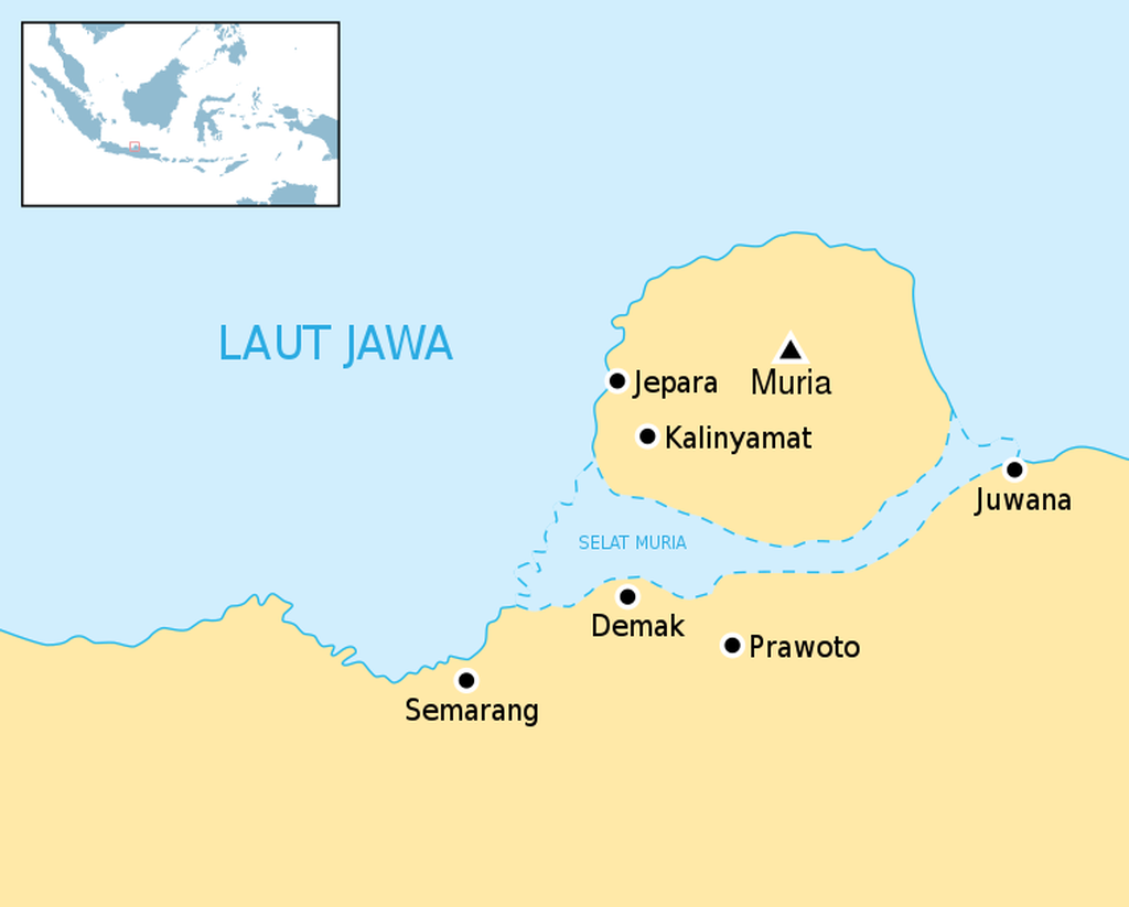
Map of the Muria Strait which separates the mainland of Java Island from Muria Island in Jepara.
History of Java
Thomas Stamford Raffles, in his notes in The History of Java (2008), also mentioned the existence of the mountain and the Muria Strait although he did not mention their names. "Another mountain to the east, namely Japara, appears to deviate further from the mountain range and forms a small peninsula in this archipelago," wrote Raffles.
The book Islamic Kingdoms in Java: The Transition from Majapahit to Mataram (1974) also mentions the Muria Strait when describing the ecology of the location of the Demak Sultanate. The Sultanate is on the shoreline of the strait which separates the Muria Mountains from Java.
Denys Lombard, in his work Nusa Jawa: Cross-Cultural Connections, Part II: Asian Network (2008), mentioned that these three regions have become crucial trade routes along the northern coast of Java.
It is also recounted that the Demak Sultanate had a trading port and a naval fleet led by Patiunus. Since the Demak Sultanate, these regions have also become an important part of the spread of Islam by the wali songo, especially Sunan Kalijaga, Kudus, and Muria.
Denys Lombard, in Nusa Jawa: Cross-Cultural, Part II: Asian Network (2008), mentions that these three regions are key trade routes on the north coast of Java. The key trade routes are situated between the Muria Mountains and the mainland of Java.
From the ancient port of Semarang, large ships can sail across the Muria Strait. The route starts from Demak, Kudus, Jepara, Pati, to Rembang, towards the ports in East Java.
Heavy equipment has been deployed to restore the levee of the Wulan River, which broke down along a 35-meter stretch, causing floods a few days ago in Karanganyar District, Demak Regency, Central Java, on Monday (12/2/2024).
Economic pulse
Until now, Semarang, Demak, Kudus, Pati, Grobogan, and Jepara have become the economic hub of Central Java, even Indonesia. For example, Semarang serves as the logistics hub due to the presence of Tanjung Emas port. Meanwhile, Demak, Kudus, Pati, and Grobogan are known as rice center regions.
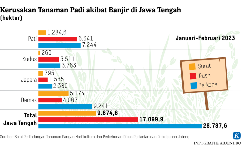
The Agriculture and Plantation Office of Central Java Province noted that as of March 15, 2024, floods have affected 16,269 hectares of rice fields in Grobogan, Demak, Pati, Kudus, and Jepara Regencies. This has resulted in a majority of the rice crops being unable to be harvested.
Also read: Floods cause rice production to fall even further and the price falls slowly
From the industrial side, Kudus is a center for the cigarette industry, while Jepara is for furniture. From a religious tourism standpoint, Demak is renowned for its Demak Mosque and the tomb of Sunan Kalijaga. Meanwhile, Kudus is famous for the mosque, tomb, and tower of Sunan Kudus, as well as the tomb of Sunan Muria.
For Semarang, Demak, Kudus, and Pati, they are also the logistics artery of the western region. During the era of Herman Willem Daendels, the Governor-General of the Dutch East Indies (1808-1811), the four areas became part of the Daendels Postal Road. Currently, the 1,000-kilometer road from Anjer-Panarukan is partially etched as the northern coastal road (pantura).
Also read: As a result of the Demak Floods, Truck Entrepreneurs Estimate Losses of Billions of Rupiah
Not surprisingly, during the recent large floods that submerged Pantura road in Semarang, Demak, and Kudus, land transportation was disrupted. Logistic transportation companies had to increase the operational costs for each truck by around Rp 100,000 to Rp 1 million per trip. This is because the trucks had to take alternative routes that were not inundated.
"Due to the Demak floods, delivery of a number of types of cargo was also hampered, especially industrial products in Jepara and Kudus. "Some of them are furniture for export and cigarettes," said General Chair of the Indonesian Truck Entrepreneurs Association (Aptrindo) Gemilang Tarigan (Kompas, 12/2/2024).
Similar things happened in 2008 and 2014. In 2008, for example, floods that submerged the Pantura road in Pati caused traffic jams along 34 km. The traffic jam started from Bareng Village, Jekulo District, Kudus Regency, then Pati Regency, to Tambakagung Village, Kaliori District, Rembang Regency (Kompas, 16/2/2008).
Then, will the series of flood events that also have an impact on the economy result in the resurgence of the Muria Strait? The Head of the Geological Agency at the Ministry of Energy and Mineral Resources, Muhammad Wafid, stated that the Muria Strait will not form solely from the floods that have hit the area.
Also read: Geological Agency Says Muria Strait Was Not Formed Due to Demak Floods
Nevertheless, the reformation of the Muria Strait could occur if there is a geological process that is catastrophic. For example, if there were a massive geological upheaval, such as a large-scale tectonic earthquake causing sudden subsidence (graben) with a wide area.
“Another factor is the decline in land levels accompanied by rising sea levels due to climate change. "However, the process takes hundreds to thousands of years," said Wafid (Kompas, 22/3/2024).
The development process of the Semarang-Demak Toll Road Section I infrastructure can be seen from above with the background of the northern waters, Semarang City, Central Java, on Monday (22/1/2024). The Semarang-Sayung toll road project will also function as a toll road and sea dyke to mitigate tidal floods.
Semarang-Surabaya toll road
To tackle this issue, the government has not yet taken significant long-term measures. Although the government has planned to build the Semarang-Surabaya Toll Road, it will only be utilized as a seawall in certain locations such as Semarang-Demak.
Currently, the newly constructed and under construction Semarang-Demak Toll Road spans 26.4 km. The completed toll road has only provided a solution for smoother transportation flow and has not touched upon flood and abrasion issues.
Also read: Environmental Impact Analysis of the Semarang-Demak Sea Embankment Toll Criticized
Strengthening river embankments that trigger floods is also still not permanent. Similarly, efforts to deal with storms and abrasion on the northern coast of Java are still spatial. One important thing that should not be forgotten is the land use change in the upstream areas that still frequently occur.
If not comprehensively handled from upstream to downstream, it is possible for the Muria Strait to reoccur. Perhaps without the need for a massive geological process to occur, right?