The Shadow of Volcanological Disasters in Indonesia
Indonesia's geomorphological characteristics contain natural resources as well as the threat of enormous disasters.
This article has been translated using AI. See Original .
About AI Translated Article
Please note that this article was automatically translated using Microsoft Azure AI, Open AI, and Google Translation AI. We cannot ensure that the entire content is translated accurately. If you spot any errors or inconsistencies, contact us at hotline@kompas.id, and we'll make every effort to address them. Thank you for your understanding.
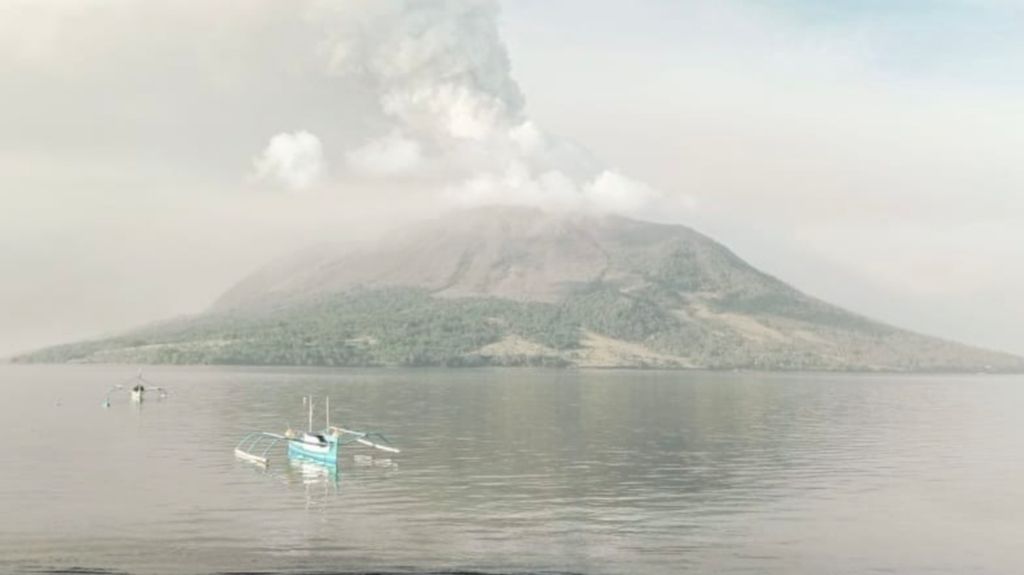
The condition of Mount Ruang in the Siau Tagulandang Biaro Islands District (Sitaro) in North Sulawesi, which spewed volcanic ash rain on Wednesday (17/4/2024).
The geomorphological characteristics of Indonesia store a wealth of natural resources as well as the potential for tremendous disasters. These potentials and threats are the result of millions of years of volcanic activity in the archipelago.
This island nation, which was formed from the meeting of three active world tectonic plates, has a row of hundreds of volcanoes. It is recorded that there are at least 127 volcanoes that form the archipelago archipelago, stretching from the western tip of Sumatra Island to the eastern tip of the Sangihe Talaud Islands.
Based on monitoring by the Geological Agency, currently there are seven volcanoes with volcanic activity status up to eruptions that endanger local residents. One volcano has risen to Level IV or Watch status, namely Gunung Ruang in North Sulawesi. Explosive eruptions occurred repeatedly from Mount Ruang until the height of the ash column reached 3,000 meters from the peak.
Six other mountains that have a Siaga (Alert) status are Mount Anak Krakatau in the Sunda Strait, Mount Awu in North Sulawesi, Mount Ili Lewotolok in East Nusa Tenggara, Mount Marapi in West Sumatra, Mount Merapi in Yogyakarta, and Mount Semeru in East Java. The Siaga status indicates an increasing volcanic activity that is becoming more noticeable, including the possibility of eruption in the near future, thus endangering the surrounding areas.
Volcanoes in Indonesia make up 13 percent of the world's total volcanoes. A total of 76 volcanoes are categorized as highly active, marked by eruption history since the 1600s until now. Based on records from the Geological Agency, there are three active undersea volcanoes, namely Buana Wuhu/Sangir, Hobal, and Emperor of China/Flores.
A series of volcanic mountains pose a significant disaster risk to humanity. The strength of volcanic eruptions in Indonesia is high, with the dominant material being the debris thrown out rather than volcanic material from within the mountain. The debris from eruptions is very dangerous, not only because of its large size, but also because of its extremely hot condition and high speed when thrown from the peak of the volcanic mountain.
One proof of the enormity of volcanic eruptions in Indonesia is the eruption of Mount Ruang in the Siau Islands Regency, Tagulandang Biaro or Sitaro, North Sulawesi, on Tuesday (16/4/2024). The Geological Agency noted that crater smoke appeared with a height of 200-500 meters from the peak on Tuesday morning. Not long after, a weak eruption occurred during the day.
Also read: Hydrometeorological Disasters and Mountain Eruptions Always Lurk in Indonesia
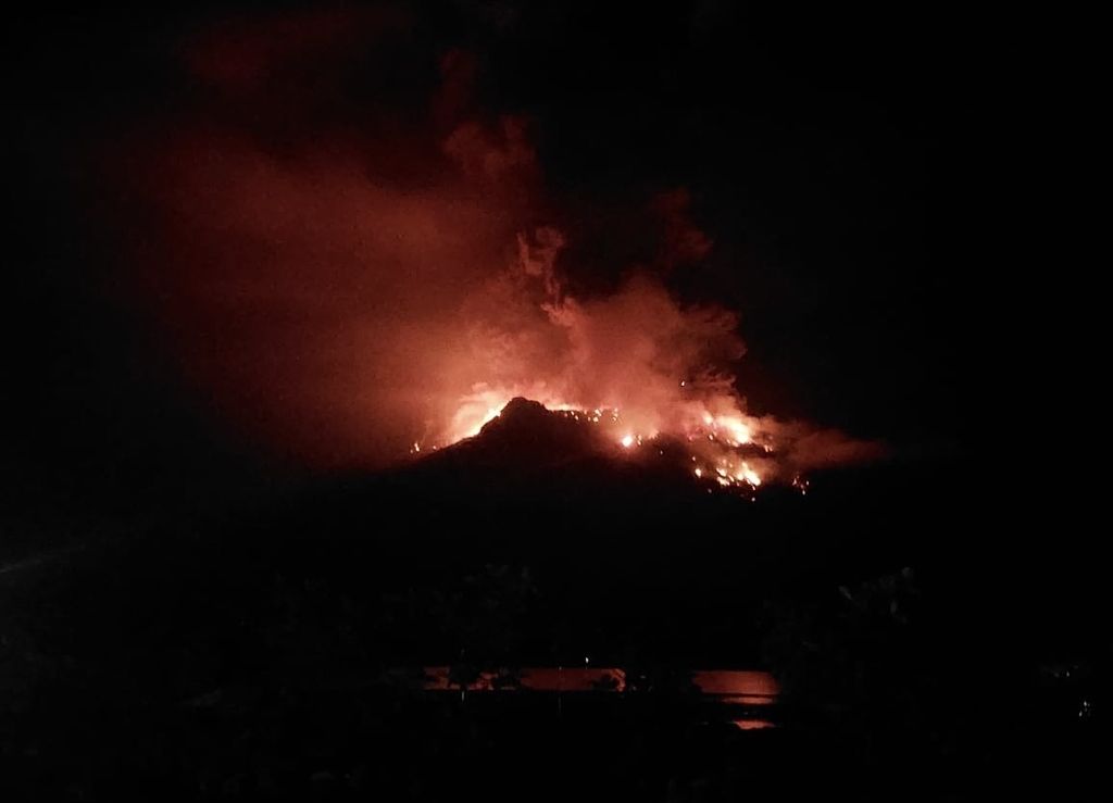
The eruption of Mount Ruang in the Siau Tagulandang Biaro Islands district (Sitaro) in North Sulawesi occurred on Tuesday (16/4/2024) evening. Hundreds of residents were evacuated.
On the night of the explosive eruption, the estimated height of the ash column reached 2,000 meters from the peak. A few hours later, another eruption occurred with a height of 2,500 meters. This second explosive eruption was accompanied by a loud rumbling and a fairly strong boom. After that, eruptions occurred periodically, with recorded columns of ash reaching heights of up to 3,000 meters.
Observations by the Geological Agency on April 1-17 stated that there had been volcanic earthquakes 2,008 times. As many as 72 percent were deep volcanic earthquakes. During the eruption period on April 16 and 17, volcanic earthquake activity increased many times over. Based on visual and instrumental observations, Mount Ruang's activity level was raised to Level IV or Alert status.
The volcanic activity has forced the evacuation of 828 people from Laingpatehi and Pumpente villages. The local regent has also declared a state of emergency through SK Bupati Sitaro Number 100/2024 for a period of 14 days, from April 16-29, 2024. The emergency period is used to accelerate the handling of disaster impacts, including the evacuation process and survivor rehabilitation.
Risk of eruption
The history of Indonesia's volcano eruptions is very long, some eruptions were even catastrophic, affecting the global climate and threatening human civilization. The eruption of Mount Tambora in April 1815 was one of the most powerful volcanic eruptions in the archipelago, even globally. If the 2010 eruption of Mount Merapi ejected 140 million cubic meters of material, Mount Tambora ejected a thousand times more material (150 billion cubic meters).
A study by Igan Supriatman Sutawidjaja in 2006, "Characterization of Volcanic Deposits and Geoarchaeological Studies from the 1815 Eruption of Tambora Volcano", revealed that the distribution of hot clouds was estimated to cover an area of 820 square kilometers with an average thickness of 7 meters. The total number of casualties reached 92,000 people in the Sumbawa and Lombok regions.
Also read: Hydrometeorological Disasters Dominate, 267 Deaths During 2023
The Tambora Mountain caldera, which has a diameter of 7 kilometers and is surrounded by steep cliffs that are 1,200 meters deep, is located in West Nusa Tenggara on Saturday (June 19, 2011).
The most catastrophic eruption ever recorded in human civilization, besides Mount Tambora, is the eruption of Mount Toba in Sumatra. The eruption happened 74,000 years ago and caused global climate disruption for up to six years. The impact of the eruption also devastated most flora and fauna species, even ancient human life at the time.
The eruptions of Mount Tambora and Toba serve as a reminder that the shadow of volcanic disasters always looms over Indonesia. The Geological Agency also notes that there are currently 76 active volcanoes across the archipelago. The 2023 IRBI document from the National Disaster Management Agency (BNPB) mentions that around 5.86 million Indonesians are vulnerable to impacts from volcanic eruptions. Economic losses are estimated at IDR 8.5 trillion, while infrastructure losses amount to IDR 3.6 trillion.
Geographically, the National Disaster Management Agency (BNPB) considers West Java as having the highest number of people at risk of being affected by volcanic eruptions, with 1.57 million inhabitants. Central Java follows with 1.19 million inhabitants. Although West Java and Central Java have the highest number of people at risk of disaster, the largest economic losses are in East Java at Rp 1.98 trillion.
Disaster mitigation
The basis for reducing the risk of volcanic eruptions is through strengthening mitigation efforts at the community level. These efforts can begin with equal understanding of the dangers and risks of volcanic disasters in the environment where people live. One instrument that can be used is the Disaster Area Map (KRB).
Also read: More than 11,000 people need to be evacuated due to the eruption of Mount Ruang
A pyroclastic cloud slid down from the slopes of Mount Sinabung in Karo Regency, North Sumatra, on Tuesday (1/11), which has been on high alert since June 2, 2015. Indonesia's most active volcano released pyroclastic clouds and eruptions up to 19 times yesterday from 00.00 to 18.00.
The danger zone is divided into three levels, namely Level I, II, and III. KRB Level III covers areas closest to the source of danger, namely the volcano crater, making it certain to be affected by hot clouds, lava flows, rock slides, and heavy ash rain. Meanwhile, KRB Level II and I are located further from the source of danger.
The eruption of Mount Ruang is a reminder of the great risk of volcanological disasters in Indonesia. Every volcanic eruption is a source of sorrow for the affected residents as well as an important lesson for everyone. Therefore, Indonesian people are required to be aware of disasters so that they have adequate adaptation and mitigation capacity. (R&D COMPAS)