Mountain Status Alert Space, Tsunami Potential Recommendation Revoked
The sterile area for community activities is a 4 kilometer radius from the peak of Mount Ruang.
This article has been translated using AI. See Original .
About AI Translated Article
Please note that this article was automatically translated using Microsoft Azure AI, Open AI, and Google Translation AI. We cannot ensure that the entire content is translated accurately. If you spot any errors or inconsistencies, contact us at hotline@kompas.id, and we'll make every effort to address them. Thank you for your understanding.
By
MACHRADIN WAHYUDI RITONGA
·3 minutes read
BASARNAS MANADO
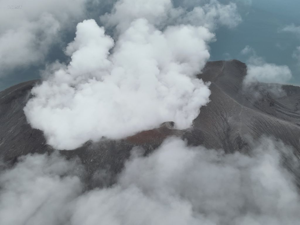
Mount Ruang in Kepulauan Sitaro Regency, North Sulawesi, erupted on Friday (19/4/2024). As a result of the eruption, the Sam Ratulangi Airport in Manado has been closed until now.
BANDUNG, KOMPAS — The status of Gunung Ruang in the Siau Islands Regency Tagulandang Biaro (Sitaro), North Sulawesi, has dropped from Watch to Alert as of April 22 2024 at 09.00 WITA. The recommendation for a potential tsunami from Mount Ruang was lifted with the area prohibited from community activities being 4 kilometers from the top of the volcano.
The Head of the Center for Volcanology and Geological Disaster Mitigation (PVMBG), Hendra Gunawan, stated that there has been a tendency for volcanic tremors within (VTA) and shallow volcanic tremors (VTB) at Gunung Ruang to decrease after the eruption on April 17, 2024. The seismic activity on Monday, between 00.00-06.00 Wita, consisted of five VTA events and 14 VTB events.
This number is lower than the previous day which reached 28 VTA incidents and 14 VTB incidents. This figure is also much lower than during the eruption, Wednesday (17/4/2024), with VTA incidents reaching 373 times and VTB 564 times. In fact, on that day there were two felt earthquakes and one local tectonic earthquake.
"In general, volcanic activity at Mount Ruang tends to be low. However, there was an escalation in volcanic activity at this mountain during the period of April 1-17, 2024. Currently, based on visual and instrumental monitoring results indicating a decline, we have lowered the level of activity at Mount Ruang from Level IV or Alert to Standby (Level III) effective from April 22, 2024 at 09.00 WIB," he said in a written statement received in Bandung, West Java, on Monday.
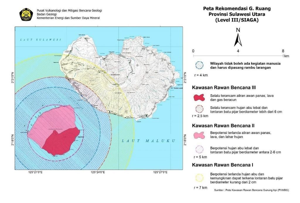
PUSAT VULKANOLOGI DAN MITIGASI BENCANA GEOLOGI
Screenshot of the recommended map of Gunung Ruang at the Alert level issued by the Center for Volcanology and Geological Hazard Mitigation on Monday (22/4/2024) at 09.00 AM local time.
This decline, according to Hendra, also has an impact on the recommendation of sterilized areas from humans around the peak of the Ruang Mountain crater. Residents are prohibited from entering a radius of 4 kilometers from the center of the active Ruang Mountain crater.
Based on the recommendation map of Gunung Ruang for Level III or Alert released by PVMBG, a small coastal area in the southwestern part of Tagulandang Island is still within the sterile zone. However, the area that is still threatened by heavy ash rain and rock projectiles with a diameter of 2-6 centimeters still reaches a radius of 5 kilometers.
The affected area includes the southwestern coastal area up to the western part of Tagulandang Island. However, the island where Mount Ruang stands is still prohibited from being entered due to a radius of 2.5 kilometers that is always threatened by heavy ash rain and projectile stones with a diameter of more than 6 centimeters.
According to Hendra, there is a buildup of eruption materials around the peak, particularly on the upper slopes of the eastern part which has the potential for rockfall or landslides. Explosive eruptions may also occur, producing a hot cloud towards the southwest, south, and southeast directions.
People are expected to remain calm and carry out their activities as usual.
BASARNAS MANADO
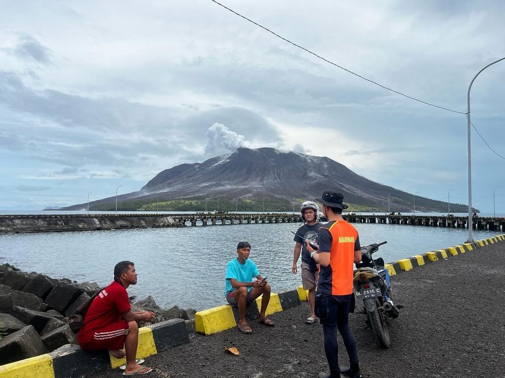
The SAR team picked up residents on the coast of Tagulandang Island for evacuation on Thursday (18/4/2024). The evacuation was carried out in stages following the eruption of Mount Ruang in the Sitaro Islands, North Sulawesi, since Tuesday night.
"The current potential danger is in the form of small-scale eruptions with limited eruption material spread around the peak. The release of potentially harmful gas is still occurring, with the scale likely decreasing as the final stage of the eruption sequence," he said.
Tsunami warning lifted
Previously, the potential tsunami recommendation when Mount Ruang erupted had also been lifted on Sunday (21/4/2024) at 12:00 Wita. According to Hendra, this withdrawal was assessed based on the decreased potential for a major eruption.
The head of the Geological Agency, Muhammad, stated that the level of activity of Mount Ruang is continuously evaluated periodically, or if there are significant changes in activity. Residents on Tagulandang Island, especially those living near the coast, are urged to be vigilant in the event of potential pyroclastic rock eruptions.
"The public is expected to remain calm and continue their activities as usual. However, they should still use masks to avoid exposure to volcanic ash that may disrupt respiratory systems," he said.