Jakarta Adds 5 Polders, Revitalizes 2 Pumps, and Builds 8 Reservoirs
Jakarta is often flooded after heavy rain with an intensity of more than 150 millimeters per day.
This article has been translated using AI. See Original .
About AI Translated Article
Please note that this article was automatically translated using Microsoft Azure AI, Open AI, and Google Translation AI. We cannot ensure that the entire content is translated accurately. If you spot any errors or inconsistencies, contact us at hotline@kompas.id, and we'll make every effort to address them. Thank you for your understanding.
By
FRANSISKUS WISNU WARDHANA DANY
·5 minutes read
KOMPAS/PRIYOMBODO (PRI)
Residents rescued belongings from their rented house which was submerged in floodwaters in Kapuk Village, Cengkareng District, West Jakarta, Friday (22/3/2024).
JAKARTA, KOMPAS — The DKI Jakarta Provincial Government built five polders, revitalized two stationary pumps, and built eight reservoirs or embungs to control floods in 2024. This construction is part of efforts to increase the capacity or capacity of flood control infrastructure, especially during heavy rain.
Jakarta often experiences flooding after heavy rainfall with an intensity of over 150 millimeters (mm) per day. One example was on Friday (22/3/2024), when flooding occurred in 55 residential areas and 30 roads after heavy rain in Semanan, West Jakarta, with an intensity of 212 mm per day and 208 mm per day in Tanjungan Pump Station, North Jakarta.
The Secretary of the Jakarta Water Resources (SDA) Agency, Hendri, stated that every year the local government continues to strive to increase the capacity of flood control infrastructure.
There is gradual construction of the polder system, improvement of river/river infrastructure and facilities, such as embankments, reservoirs or embungs for water retention, and canalsdrainage in flood-prone areas. Increasing this infrastructure capacity certainly requires coordination with other departments or agencies.
"This year five polders are being built, two stationary pumps are being revitalized, and eight reservoirs/reservoirs are being built," said Hendri, Tuesday (26/3/2024).
The five polders are Sunter C Pump, Gaya Motor Pump, Kali Sepatan Pump (Nusantara Bonded Zone), IKPN Bintaro Pump, and RW 13 Greenville Pump. Meanwhile, pump revitalization is currently underway at the Stationary Pump on Tanjung Duren Raya-Jalan S Parman in West Jakarta and Taman BMW Stationary Pump in North Jakarta.
As for the eight reservoirs/ponds, they consist of six ongoing developments, namely Marunda Reservoir, Dukuh 2 Reservoir, Munjul Reservoir, Cilangkap Reservoir, Kaja pond revitalization, and Pekayon pond completion, as well as two new ponds, namely SDN 01 Petukangan Selatan pond and Jalan Pemuda Srengseng Sawah pond.
Apart from that, plans are underway for the normalization of the Semongol River, Gendong River waterway, and dredging to anticipate flooding in West Jakarta. This plan is included in the priority program for 2025.
KOMPAS/AGUS SUSANTO
Residents pass by the Ciliwung River water pump in Kebon Baru Village, Tebet, South Jakarta, Tuesday (7/11/2023).
Hendri stated that the plan for normalization and culvert cleaning is still under study. After the study results are released, preparations for the work process in the field will follow.
"The normalization of the Semongol River and the Gendong River watershed are currently being studied for planning," said Hendri.
The DKI Jakarta SDA Department also routinely dredges rivers, reservoirs and water channels to remove mud sediment so that the channel capacity remains optimal in holding water, as well as installing sheet piles or embankments on the sides of the river/river.
The installation of these embankments is aimed at addressing landslides around rivers and streams. The locations include Kali Pesanggrahan in West Jakarta and the Kali Sunter segment at the Pompa Pulomas in North Jakarta.
Rain must be managed with good and appropriate infrastructure.
Hendri added that another effort is by accelerating the construction of the National Capital Integrated Coastal Development (NCICD) Phase A coastal protection embankment. The embankment is to overcome tidal flooding in the coastal areas of North Jakarta.
"The development of NCICD Phase A is being carried out in Muara Angke, Pantai Mutiara, Sunda Kelapa Kelapa-Ancol Barat, and Kali Blencong (Cilincing-Marunda area)," said Hendri.
KOMPAS/TOTOK WIJAYANTO (TOK)
UPK officials from the Environmental Agency of DKI Jakarta used an excavator to dredge mud and catch water hyacinths present in the Pluit Reservoir on Tuesday (30/1/2024).
Rain management
Flood control system is part of integrated rain management. Rain is managed for its entire spectrum, ranging from light rain to heavy rain.
The Meteorology, Climatology, and Geophysics Agency classifies daily rainfall intensity as follows: less than 5 mm (very light), 5-20 mm (light rain), 20-50 mm (normal/moderate rain), 50-100 mm (heavy rain), more than 100 mm (very heavy rain).
Professor of Hydrology at the Faculty of Engineering, University of Indonesia, Dwita Sutjiningsih stated that each classification of rain has its own management technique and infrastructure to manage it properly. Light to moderate rain generally occurs more frequently than heavy rain, as recorded at the FTUI Rain Station, with a recording average of 67 percent from 2003-2022.
"Rain should be managed with good and appropriate infrastructure. Especially since one third of heavy rainfall causes puddles here and there, which is the easiest thing for people to complain about," said Dwita.
Very light to moderate rain is managed through infrastructure that is designed to absorb rainwater into the ground as a source to replenish groundwater reserves. Meanwhile, infrastructure to manage one-third of heavy and very heavy rain, in conventional paradigms, is referred to as a drainage system.
The main drainage system in Jakarta, namely West Flood Canal and East Flood Canal, was designed for a 100-year flood, while other channels were designed for a flood frequency of 25 to 50 years. It is no wonder that when there is rain exceeding the design flood frequency, there will be overflow causing puddles and even floods.
"In Jakarta, there is a drainage system that relies solely on gravity, making pump assistance and a reservoir known as a polder system necessary in the northern part where land elevation is below sea level," said Dwita.
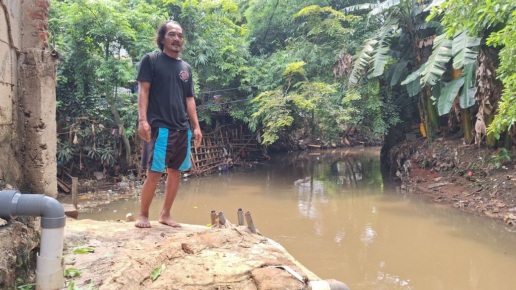
FRANSISKUS WISNU WARDHANA DANY
The homes of residents adjacent to Krukut River in RT 003 RW 003 of Cilandak Timur Village, Pasar Minggu District, South Jakarta, on Wednesday (10/1/2024). There has been no drainage or normalization, resulting in frequent flooding from the overflowing river.
Regarding the normalization of rivers, a lecturer at the School of Environmental Sciences at the University of Indonesia stated that the term normalization can be interpreted in multiple ways. In technical hydrology, normalization involves dredging in such a way that the cross-sectional profile of the river is able to accommodate planned discharge.
For example, the segment of Ciliwung River at Manggarai Water Gate, based on the calculation of Jakarta Flood Control System prepared by Netherlands Engineering Consultants (NEDECO) in 1973, for a recurrence interval of 100 years is 370 cubic meters per second.
However, it should be noted that the condition of land use in the river basin (DAS) dates back to the 1970s. This means that after half a century has passed, it has changed significantly.
"Most land cover has become impermeable (residential areas, industrial areas, and roads). Therefore, for the same amount of rainfall, it will result in much larger runoff. If the river channels are not normalized, they will not be able to handle the much larger runoff," said Dwi.
Editor:
NELI TRIANA
Share
Kantor Redaksi
Menara Kompas Lantai 5, Jalan Palmerah Selatan 21, Jakarta Pusat, DKI Jakarta, Indonesia, 10270.
Tlp.
+6221 5347 710
+6221 5347 720
+6221 5347 730
+6221 530 2200
Kantor Iklan
Menara Kompas Lantai 2, Jalan Palmerah Selatan 21, Jakarta Pusat, DKI Jakarta, Indonesia, 10270.