Indonesia Entering Transition Season, Beware of Extreme Weather
The public needs to be aware of extreme weather events throughout the current transition period.
This article has been translated using AI. See Original .
About AI Translated Article
Please note that this article was automatically translated using Microsoft Azure AI, Open AI, and Google Translation AI. We cannot ensure that the entire content is translated accurately. If you spot any errors or inconsistencies, contact us at hotline@kompas.id, and we'll make every effort to address them. Thank you for your understanding.
The following article was translated using both Microsoft Azure Open AI and Google Translation AI. The original article can be found in Indonesia Memasuki Musim Pancaroba, Waspadai Cuaca Ekstrem
The Importance of Adaptation and Mitigation Knowledge When a Tornado Occurs
Currently, Indonesia is entering a season transition period from rainy to dry or what is called transition. The public needs to be aware of extreme weather events throughout this transition period.
The Meteorology, Climatology, and Geophysics Agency (BMKG) encourages the public to be aware of the potential for extreme weather during the period of pancaroba estimated to take place from March to April 2024. Head of BMKG Dwikorita Karnawati conveyed that early anticipation of extreme weather, from brief heavy rains, hail, to tornadoes, should be increased (Sunday, 25/2/2024).
Seasonal forecast in 699 regions in Indonesia indicates that the rainy season will occur from October 2023. This wet period will reach its peak in early 2024, around January and February. During this period, almost all of Indonesia's regions will be showered with various intensities of rain.
BMKG analysis at the end of February 2024 indicates that several regions in Indonesia have passed the peak of the rainy season, especially in the southern part of the equator. This shift in season is characterized by strong atmospheric dynamics. One of the signs is a pattern of rain in the afternoon and evening, preceded by warm and scorching air in the morning until noon.
Extreme weather changes from morning to afternoon occur due to the process of convection from the Earth's surface to the atmosphere. This process occurs because the amount of solar radiation received by the Earth's surface is large enough to lift the air mass and trigger the formation of rain clouds. These rain clouds will trigger rainfall with moderate to heavy intensity in a short duration.
Also read: The High Potential for Tornado Disasters in Indonesia
Several residents used umbrellas while walking on Margonda Street, Depok City, West Java, on Saturday (13/1/2024). Heavy rain accompanied by lightning poured down on Depok City on Saturday afternoon. The flashing lightning prompted some residents to take shelter in several shops. The Meteorology, Climatology, and Geophysics Agency predicted that Depok City would be hit by rain from noon until evening.
Dwikorita also stated that if the atmospheric conditions become unstable, the potential for the formation of convective clouds, such as cumulonimbus, will increase rapidly. The characteristics of these clouds are shaped like cauliflower in grayish color and have a clear or sharp edge boundary. Cumulonimbus is very dangerous because it is closely related to lightning, strong winds, and tornadoes.
Heavy rainfall is the main factor triggering hydrometeorological disasters in a number of regions in Indonesia. Flash floods and landslides have become commonplace and pose a risk to communities, especially those living in hilly areas. Other extreme events are strong winds and tornadoes which can damage houses and other public facilities.
According to a report by the National Disaster Management Agency (BNPB), from January to February 26 2024 there were at least 350 natural disasters in the country. The most numerous were flood disasters with 221 incidents and disasters due to extreme weather with 86 incidents. Natural disasters at the beginning of this year killed at least 42 people and displaced around 1.5 million residents.
Atmospheric anomalies
Apart from the transition period or pancaroba, BMKG also stated that there are several other significant atmospheric phenomena that trigger an increase in rainfall accompanied by lightning and strong winds in Indonesia. The first phenomenon is the dominant Asian monsoon activity. The Asian monsoon will continue to trigger the formation of rain clouds, especially in central and southern parts of Indonesia.
Monsoon Asia is an annual phenomenon that occurs due to the wind blowing from the Asian region to Australia. This occurs because of the annual apparent position of the sun between October to April, which is in the southern hemisphere, making the Asian region much cooler. Cooler temperatures are always accompanied by higher air pressure, causing air or wind to move towards warmer regions or lower air pressure areas.
Due to the wind that blows from the Asian region, taking in a mass of air from the convection process in the Pacific Ocean, Indonesia will receive a lot of rain clouds. This condition is what causes heavy rain in various areas from Sumatra to Papua.
Also read: Wind Tornado, the Second Most Frequent Natural Disaster in Indonesia
Fog enveloped the towering building during heavy rain on MH Thamrin Street, Central Jakarta, on Thursday (11/1/2024). The Meteorology, Climatology, and Geophysics Agency predicted that light and heavy rain, as well as extreme weather, could potentially occur until mid-January 2024 in several regions of Indonesia.
The second phenomenon is the activity of the Madden Julian Oscillation (MJO) in quadrant three or the Eastern Indian Ocean region. The activity will spread to the western coastal areas of Indonesia in the coming weeks, marked by an increase in rain cloud growth. In some phases, MJO even contributes to the acceleration of El Nino and La Nina cycles worldwide.
Apart from the Asian monsoon and MJO, Deputy of Meteorology at the BMKG, Guswanto, said that the increased risk of extreme weather also occurs due to the presence of atmospheric waves around the southern, central, and eastern parts of Indonesia. Another factor is the formation of turning patterns and the meeting of winds that stretch across central and southern parts of Indonesia.
Anticipate extreme weather
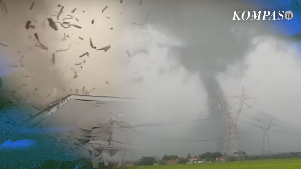
The unstable atmospheric conditions have caused many extreme weather events on the surface of the Earth. One of the events that endangers the community is the phenomenon of a tornado in the Rancaekek area, West Java, on February 21, 2024. In fact, some refer to this phenomenon as a tornado due to its similarity in shape to those that occur in subtropical regions, such as the United States.
Tornado is just one of several disaster incidents that arise due to extreme weather. Other disasters are flash floods, inundation floods, and landslides.
The public needs to be vigilant by recognizing the characteristics of atmosphere conditions that are at risk of causing extreme events. One thing that can be observed is the occurrence of strong heating between 10.00am to 14.00pm, which will be followed by the formation of dark colored clouds with shapes resembling cauliflower.
Also read: Hydrometeorological Disasters and Mountain Eruptions Always Lurk in Indonesia
Overcast loomed in Bekasi, West Java, on Saturday (13/1/2024). During the January 2024 period, there were several atmospheric dynamic phenomena that could trigger the potential for extreme weather in some areas of Indonesia. Hydro-meteorological disasters are predicted to still dominate in 2024.
The dark and flower-shaped cloud is a cumulonimbus. Everyone who is outside should immediately seek shelter in a building or home. If they must remain outside, they should stay away from power poles, trees, bridges, billboards or tall buildings that have the potential to collapse, and then quickly find a place to take cover.
If you are inside a building or a house during extreme weather, close all doors and windows tightly. Then, turn off all electricity in the building or house, and find a safe place away from doors or windows. All of these precautions are taken to prevent casualties due to extreme weather.
For the central and regional governments, early anticipation needs to be done through several ways. First, ensuring that the capacity of infrastructure and water resource management systems are ready to anticipate the increase in rainfall.
Secondly, conducting integrated environmental arrangements, such as trimming the branches or twigs of large trees and strengthening the standing of advertising poles or billboards.
Lastly, build integrated communication between government agencies and create an early warning system. The government must also monitor information regarding developments in extreme weather. (R&D COMPAS)