Java Coast Suffers Unrelenting Wave Pounding
It was Monday (20/6/2022), and Nuramah (66) jumped up from her seat when seawater washed over the backyard of her house in Gebang Ilir village, Cirebon regency, West Java.
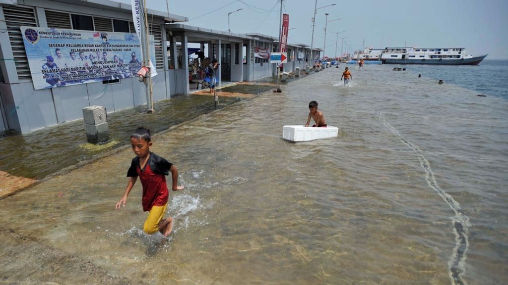
Tidal flood as high as 10-15 cm inundated the Kali Adem pier, Muara Angke, North Jakarta, Wednesday (3/1/2018).
The Russia-Ukraine war has brought about adversity in global geopolitics, with dozens of countries feared to be enduring pervasive repercussions. No less concerning is the ecological threats caused by climate change that the world is facing. In Indonesia’s case, one of these threats concerns extensive swathes of Java’s northern coast being swept away by pounding waves from the sea.
It was Monday (20/6/2022), and Nuramah (66) jumped up from her seat when seawater washed over the backyard of her house in Gebang Ilir village, Cirebon regency, West Java. The regency is one of those located on Java’s northern coast, locally known as pantura.
Nuramah, who has 16 grandchildren, rushed to plug the drainpipe from which the water was entering with a rock and plastic bag that she had prepared.
This is what she does every time the tidal flood comes in. That day, murky water flowed in from the estuary located only 5 meters from her house, while the sea is 1 kilometer away.
Also read:
> Guardians of the Semarang Coast
When the sea level rises, the tidal flood inundates her house to a height of more than 30 centimeters. That Monday and also the week before, the flood submerged residential roads to more than 60 centimeters high. "Returning home from selling crab, I found that the house was flooded," Nuramah said.
She grew sad when she recalled how hard her late husband had worked to be able to afford those items.
In addition to disrupting her daily activities, the flooding has damaged her furniture and home appliances. The bottom of the refrigerator has rusted quickly as a result, while the legs of her wooden cabinets and tables have become worn out from constantly standing in water. She grew sad when she recalled how hard her late husband had worked to be able to afford those items.
Sulaeman, head of the local disaster response task force, said more than 100 homes in the village’s Balong and Karangdogolan clusters were vulnerable to tidal flooding, which had increased in risk after 2000. At that time, the water had yet to spill over into the residential areas.
Nuramah did not appear to be aware of what was causing the flooding. She could only recall that the area used to be full of mangroves and fish ponds when she built her house in 1984. The area had now turned into a residential settlement.
Some of the new housing developments have been built with elevated floors to keep them safe from the flooding. However, there was no guarantee of this.
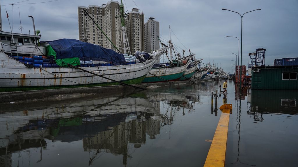
The atmosphere of the Sunda Kelapa Harbor area, Jakarta, when flooded by tidal waves, Sunday (5/12/2021).
“That house is empty again. The resident moved to his sibling's house,” said Nuramah, pointing to a semipermanent house across hers. She said she felt tired of cleaning her house.
In fact, she has also had her house elevated during a renovation that used 10 truckloads of sand that cost tens of millions of rupiah.
Dani (36) lives in Panjang Baru village of Pekalongan regency, Central Java, also along the island’s northern coast. The father of three was dismayed at the recurring floods, saying that it happened almost every month, especially when the moon was full. The floodwaters could reach up to 1.5 meters and take several days to recede.
To prevent flooding, Dani and his neighbors have had to elevate the floors of their houses almost once every year. The distance between the floor and ceiling of his house was 5 meters when it was built 11 years ago, but it is now just 2 meters. The windows are barely visible.
The doors are now half their original heights. Dani has to bend down to pass through a door, now only around a meter tall.
“People elsewhere spend money on new clothes, good food, and other luxuries. Well, we use our money to buy building materials to retile the house,” said Dani.
The building materials for elevating a house comprise sand, rocks, and soil. Dani hoped to find a solution to be free from the flooding.
The residents of neighboring North Semarang are experiencing depressing living conditions, with the people unable to afford elevating their houses now resigned to their fate.
Many more houses are facing inevitable inundation. So are the rice fields in Tegal and Brebes regencies.
In Bedono and Sayung of Demak regency, the conditions have become worse with a sizable tract of land already now a cove. Several abandoned houses and a community hall are permanently inundated by seawater. Many more houses are facing inevitable inundation. So are the rice fields in Tegal and Brebes regencies.
Pekalongan and Semarang have so far been the hardest hit by tidal flooding along Java's northern coast. Land subsidence is quite severe in the two regions. Data from the National Institute of Aeronautics and Space (Lapan) show that in 2015-2020, Pekalongan recorded an annual land subsidence rate of 2.1-11 cm. Over the same period, the annual subsidence rate in Semarang was 0.9-6 cm.
In East Java, tidal flooding is forecast to hit regions bordering the Java Sea bordering in Surabaya, Sidoarjo and Gresik between July and December.
The Gresik Disaster Mitigation Agency (BPBD Gresik) recently reported that at least 167 houses and 577 hectares of fish ponds had been inundated by tidal flooding for almost a week from Monday (13/6/2022). The houses and fish ponds are located in the five districts of Manyar, Kebomas, Ujungpangkah, Bungah, and Tambak on Bawean Island.
“The worst tidal flooding occurred in Ujungpangkah district. Many houses were submerged more than 50 centimeters deep," said BPBD Gresik head Tarso Sugito.
In Sidoarjo, tidal flooding has affected hundreds of hectares of milkfish breeding ponds in the districts of Sedati, Buduran, and Jabon. The floodwaters, exacerbated by heavy rain, flowed up the river from the coast as far as 18 km inland.
"The flooding this time was the worst compared to the previous years," said Jenny (45), a resident of Pondok Tjandra.
Estimated losses
Tidal flooding is not exclusive to Java’s northern coast. Using the simulation of climate science media website Climate Central, Kompas has identified 199 out of Indonesia’s total of 514 regencies and municipalities, including 21 provincial capitals, which will see more than 2 percent of their areas submerged. Some of these areas are located below sea level, making them prone to the sea level rise. Annual tidal flooding is expected to cause extensive impacts.
Sea levels around the world have been reportedly rising for the last 100 years, with the impacts predicted to increase in severity by 2050.
Overall, as much as 118,000 ha of land will become inundated and 8.6 million people will be affected in those 21 regencies and municipalities. Economic losses are estimated at Rp 1.576 quadrillion (Kompas, 20 Aug. 2021).
Heri Andreas, head of the Disaster Research Institute of the Bandung Institute of Technology (ITB) Alumni Association, said that climate change, the tides and land subsidence were the causes of tidal flooding. "More and more areas will be affected. In Indonesia, the areas affected by tidal flooding are located in 112 regencies and municipalities," he said told a discussion forum on "Restoration of the Mangrove Ecosystem in the Northern Coastal Area of Mayangan Village, Subang Regency".
The subsidence rate on Java’s northern coast is relatively high. In Jakarta, the subsidence rate is 1-11 cm per year, while it is20 cm per year in Pekalongan, Semarang and Demak. In Cirebon, it is 1-3 cm per year.
"Tidal flooding on the northern coast is threatening tens of thousands of hectares and hundreds of thousands of people. They will be displaced from their homes. It is projected that by 2030, around 80 percent of land in Pekalongan will subside to below sea level. So will Semarang, Demak, and Indramayu," said Heri, a geodesy expert from the ITB School of Geological Sciences and Technology.
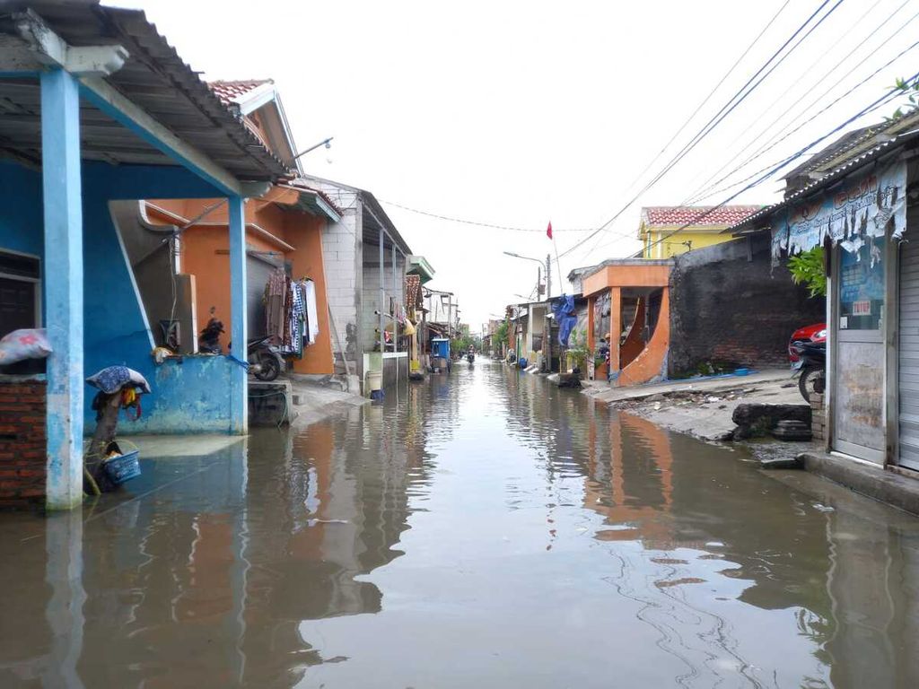
Residents' settlements were submerged by tidal flooding in Tambaklorok Village, Tanjung Mas Village, Semarang City, Central Java, Wednesday (25/5/2022).
Heri said the high subsidence rate was partly due to groundwater exploitation and that efforts needed to be made to stop the exploitation of groundwater.
Recommendations, actions
Speaking about the measures to address the situation, Siti Sumilah Rita Susilowati, who heads the Geological Agency’s Center for Groundwater and Environmental Geology at the Energy and Mineral Resources Ministry, recommended that local governments in tidal flooding hazard zones map the distribution and depth of soft soil in the area, as well as measure and monitor the subsidence rate.
The measures should also include prioritizing the use of surface water and controlling the use of groundwater in line with the designated conservation zone. Spatial and infrastructure development plans must be made in line with geological subsurface engineering of areas with soft soil.
In the last few weeks, a number of regional heads from northern coastal regions in Central Java gathered to discuss the risk of tidal flooding. They elaborated on the current situation of tidal flooding and its impacts in each regency. Short, medium and long-term integrated management master plans would be drawn up based on the prevailing conditions and feedback from participants.
Nomastuti Junita Dewi, the secretary of the Central Java Regional Development Planning Agency, said that the short-term plan to deal with tidal flooding was to raise the height of breakwaters, deploy buoys, install onshore ports, and construct the Semarang toll road. The work was estimated to finish in three years.
The medium-term plan, which was expected to be realized in the two years following the first phase of development, aimed to stop groundwater exploitation. "We can't rush the order to ban [groundwater use by] the community. An alternative water source must be provided," she said.
The long-term master plan was to prepare for coastal management, which would include integrating spatial plans for sea and land, mapping vulnerable areas, conservation areas, and safe areas for residential settlements and industrial centers. The map would be the guideline for coastal planning.
On several occasions, Central Java Governor Ganjar Pranowo has reminded the local administrations of coastal regions to deploy patrols and map embankments that might collapse and urged them to elevate embankments if necessary to prevent tidal runoffs.
"In Pekalongan, the sea wall [development] is still in progress. We are also going to build the Semarang-Demak toll road here to mitigate tidal waves," he said, adding that strict regulations would be needed to curb groundwater exploitation.
Luhut said he would speak with Public Works and Housing Minister Basuki Hadimuljono about the condition of tidal flooding in Central Java.
In early June, Ganjar met with Coordinating Maritime Affairs and Investment Minister Luhut Binsar Pandjaitan to discuss the issue. Luhut said he would speak with Public Works and Housing Minister Basuki Hadimuljono about the condition of tidal flooding in Central Java.
"I have reported the issue to the President. I have also talked to Pak Basuki. We are now preparing the design," said Luhut.
Meanwhile, the East Java provincial administration has been accelerating mangrove planting and coastal forest restoration as part of its long-term plan. Governor Khofifah Indar Parawansa said 136,600 mangrove seedlings had been planted on 42.75 ha in 2021. The seedlings were planted in targeted locations including Gresik, Pasuruan, Probolinggo, and Bangkalan.
Khofifah said this year’s target for the mangrove ecosystem rehabilitation project was 95 ha, which was funded by the provincial administration, and 1,250 ha funded by the Environment and Forestry Ministry.
The environmental program is stipulated in a circular the governor had distributed to regents and mayors, as well as state-owned enterprises, both national (BUMN) and local (BUMD).
Meanwhile, the Jakarta provincial administration has built a giant embankment north of Jakarta Bay to tackle tidal flooding. According to the National Capital Integrated Coastal Development (NCICD) program, the embankment is to be 120.1 km wide. In 2015-2019, only 9.25 km was built, below the projected development of 20.1 km in the first phase. The Public Works and Housing Ministry built 4.830 km and the Jakarta government 4.42 km, while the private sector is yet start constructing its section. "We will continue with the program," said Jakarta Deputy Governor Ahmad Riza Patria.
The NCICD embankment development project is estimated to cost Rp 600 trillion in allocations from the state and regional budgets.
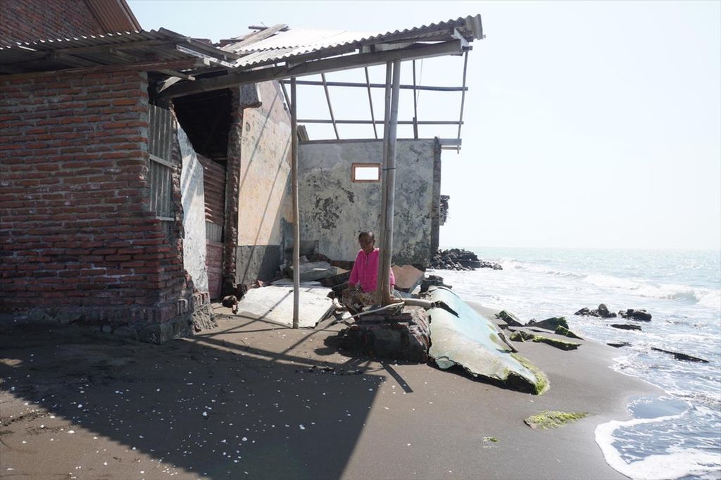
Samah (60), a resident of Sidaharja Village, Suaradi District, Tegal Regency, Central Java is in the rubble of her house which collapsed under the sea water.
The cost is huge, but the severity of the disaster risk is unthinkable for Jakarta alone by 2050 because without mitigation, tidal flooding could potentially be a hazard to the city center, with economic losses reaching an estimated US$200 billion (Rp 2.361 quadrillion). At least 1.5 million jobs could also be lost, as residents will be forced to move to safer areas (Kompas.id, 20 Aug. 2021).
Without additional disaster management policies, the tidal flooding that has already affected ordinary people like Nuamah and Dani is likely to turn the land where we now live in safety into part of the sea in the next 20-30 years (GESIT ARIYANTO)
(This article was translated by Musthofid)