La Niña Grows Stronger, Weather Grows More Erratic
The Meteorology, Climatology and Geophysics Agency (BMKG) is continuing to monitor La Niña as it grows stronger in Indonesia. The archipelago is likely to see a late dry season because of the weather phenomenon.
By
Kompas Team
·6 minutes read
KOMPAS/IWAN SETIYAWAN
Dark clouds hung over the sky just before heavy rains hit the Central Jakarta area, Thursday (17/3/2022).
JAKARTA, KOMPAS – The weather phenomenon La Niña, which has persisted for the last two years and had weakened since January 2022, has now come back stronger. Aside from pushing back the dry season further than predicted, some parts of Indonesia may also see increased rainfall due to the phenomenon.
Several areas across the country that should have transitioned into the dry season are still experiencing high rainfall. However, Siswanto, a climate researcher and the BMKG climate and air quality information head, explained that the increased rainfall seen over the last few days in Java, including Greater Jakarta, has also been triggered by regional conditions and daily weather dynamics.
This increased rainfall had prompted higher vigilance in several municipalities, such as Tangerang and South Tangerang in Banten. The BMKG also forecast a chance of moderate to heavy rain accompanied by lightning and strong winds for Banten until Tuesday (31/5/2022).
In Central Kalimantan, the South Barito regency administration imposed a 14-day emergency alert status for floods, landslides and tornadoes.
To year-end
Siswanto explained that long-term forecast models from various international climate assessment institutions suggested the possibility that La Niña could last until the end of the year. “This means that La Niña could persist for three consecutive years,” he said in Jakarta on Sunday (29/5).
La Niña has affected the Pacific Ocean for the last two summers. The first event lasted between the end of September 2020 and March 2021, while the second event developed in November 2021 and is ongoing.
According to Siswanto, the latest El Niño-Southern Oscillation (ENSO) prediction models showed a probability of 62 percent that a weakened La Niña phenomenon could last until June or August 2022. The phenomenon was expected to continue into autumn with a 55-60 percent chance into early winter in the Northern Hemisphere.
“But there are also different models with indications towards [a return to] normal conditions,” he said.
BMKG climate variability analysis coordinator Supari said that La Niña had grown stronger in intensity since March. Between January and February, the ENSO index was between minus 0.9 and minus 0.8, indicating a decrease in intensity.
However, from March to May, La Niña again grew stronger, with the ENSO index reaching minus 1.1, indicating moderate intensity. “Up until 2 May, the ENSO index reached minus 1.12,” said Supari.
He added that three-year La Niña episodes were relatively rare. “Throughout history, from 1950 there have been eight prolonged La Niña events, two of which lasted three consecutive years, namely in 1973, 1974 and 1975 as well as in 1998, 1999 and 2000,” he said.
BMKG
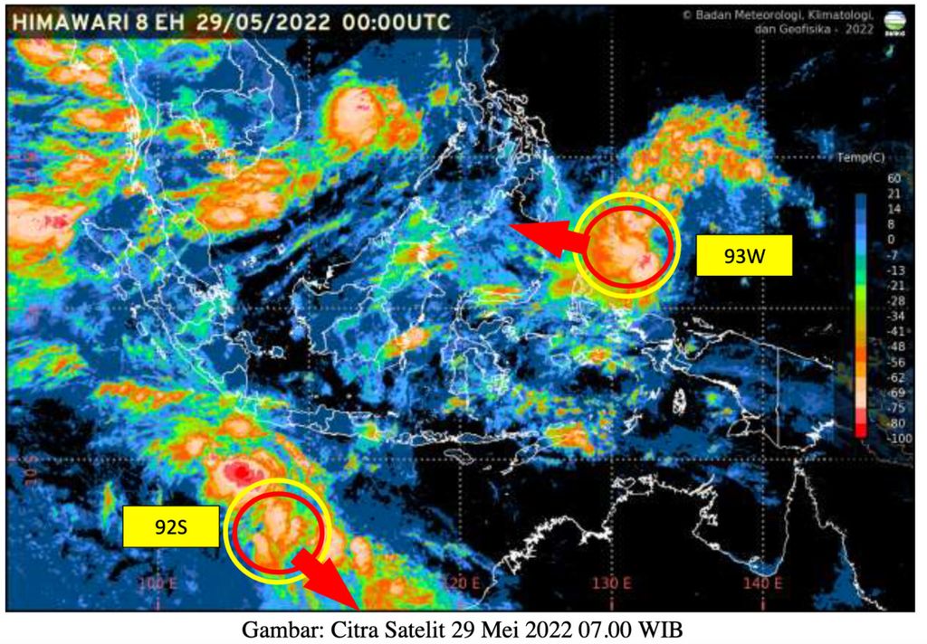
Two cyclone seeds, 92 S and 93 W were detected around Indonesian waters. This triggers an increase in the intensity of rain, strong winds, and high waves. Satellite Image May 29, 2022. Source: BMKG
Dry season impacts
Supari explained that the prolonged La Niña phenomenon was expected to affect the dry season in Indonesia. “When we forecast the dry season in February 2022, we took into account the [humidity] during the dry season this year, which caused most areas to experience a delayed dry season,” he said.
However, the weather forecasts at that time assumed that the ENSO conditions would remain neutral in the second half of the year. Recent monitoring suggests the potential for La Niña to persist in the latter half of the year, with indications that the dry season may start later than expected, with wetter conditions than expected.
In its earlier dry season forecasts made in March 2022, the BMKG predicted that based on the 1991-2020 climatological average, 163 seasonal zones, or 47.7 percent of all zones, would experience a delayed dry season. A total of 90 seasonal zones (26.6%) experienced the regular arrival of the annual dry season, while 89 zones (26%) saw an early dry season.
Siswanto added that the country had seen increased rainfall, as La Niña had grown stronger since early March. However, the recent increase in rainfall across parts of Java, including Greater Jakarta, was also influenced by regional conditions and daily weather dynamics.
Cyclone seeds
According to BMKG data, several regions in the country, including Greater Jakarta, had seen moderate to heavy rainfall in the last two days.
“This increase in rainfall was a result of the indirect impact of two cyclone seeds observed around Indonesia, namely the 92S and 93W cyclone seeds,” said BMKG weather forecasts and early warning coordinator Miming Saepudin.
According to Miming, cyclone 92S seeds were found in the Indian Ocean south of West Java with a maximum wind speed of 20 knots and a minimum air pressure of 1005.8 millibars (mb).
KOMPAS/AGUS SUSANTO
Road users are careful crossing puddles on Jalan Raya Kalimalang, Duren Sawit, East Jakarta, Friday (20/5/2022). Heavy rains and poor drainage resulted in a number of puddles on the roads.
These cyclone seeds, Miming continued, could trigger an increase in the chance of moderate to heavy rainfall in Bengkulu, Lampung, Jakarta, Banten, West Java and Central Java. Strong winds with speeds exceeding 25 knots could potentially occur in Bengkulu, Lampung, Banten and West Java.
Additionally, waves reaching 2.5-4 meters in height could occur in the Indian Ocean to the west of Lampung as well as to the south of Banten, in the southern waters of the Sunda Strait, the waters south of Java and the Indian Ocean to the south of East Java. Waves reaching heights of 4-6 m could also occur in the Indian Ocean to the south of West and Central Java.
Miming added that the 93W tropical cyclone seed had also formed in the Philippine Sea to the north of West Papua with a maximum wind speed of 15 knots and minimum air pressure of 1010.3 mb. The potential for this seed to develop into a tropical cyclone in the next 24 hours was still low. However, it could still cause moderate to heavy rainfall in North Sulawesi, North Maluku and West Papua.
Increase vigilance
The Banten Regional Disaster Management Agency (BPBD) reported that flooding had receded in several places in the municipalities of Tangerang and South Tangerang after heavy rainfall on Saturday (28/5). However, increased vigilance was still needed, as the BMKG had forecast a potential for moderate to heavy rain in Banten until Tuesday (31/5), possibly accompanied by lightning, thunder and strong winds.
Prevention head Urip Supri Yatna of the South Tangerang BPBD said he would continue to monitor areas prone to flooding and issue warnings on rainfall, floodwater and areas that could be affected.
Residents have been advised to store important belongings in a safe place, limit activities outside the home and prepare emergency kits containing food, drink, medicine, money, a change of clothes and important documents.
“If you are outside the home, avoid large trees, billboards and drains because they can be dangerous during extreme weather,” added Urip.
Tangerang city BPBD head Deni Koswara was also continuing to coordinate with the local public works and housing agency to clear rivers and make sure water pumps were functioning. (AIK/DAN/HLN/IDO)