South Kalimantan Flood a Gloomy Picture of Natural Destruction
Massive recent floods have affected thousands of residents in South Kalimantan. Apart from extreme rainfall, the floods were also caused by environmental damage on the island.
By
kompas team
·6 minutes read
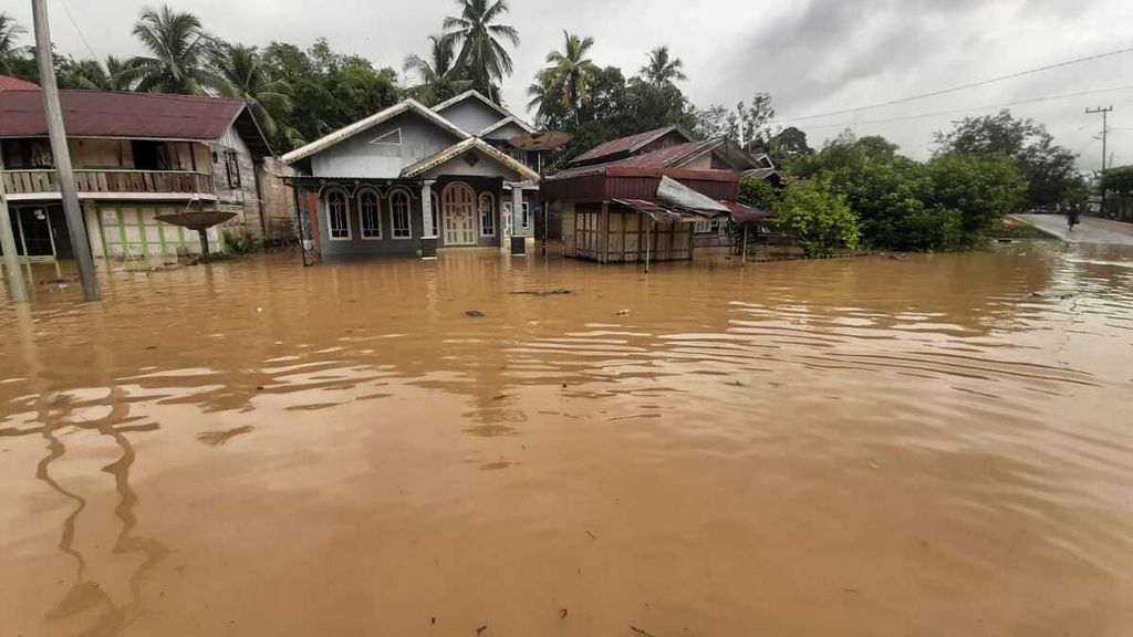
KOMPAS/JUMARTO YULIANUS
Residents chat on the porch of a house in Sungai Lulut Village, East Banjarmasin District, Banjarmasin City, South Kalimantan, on Sunday (24/1/2021).
Massive recent floods have affected thousands of residents in South Kalimantan. Apart from extreme rainfall, the floods were also caused by environmental damage on the island.
BANJARMASIN, KOMPAS — Massive floods that hit South Kalimantan at the beginning of this year were not only caused by extreme rain, but also due to damaged water catchment areas. In the upstream area, forest degradation due to mining activities and monoculture plantations has been going on for a long time. Meanwhile, in the downstream area, forest land has been changed into residential areas.
The floods, some of which lasted for two weeks with a height of more than 1 meter, inundated 11 of 13 regencies/cities in South Kalimantan. Only the regencies of Tanah Bumbu and Kotabaru were not affected.
Up until Sunday (24/1/2021) afternoon, according to the South Kalimantan Flood Emergency Response team, 712,129 people were affected by the floods, and 113,420 of them were displaced. Twenty-four people have been killed and three are missing.
The floods submerged 122,166 houses, 609 places of worship and 628 schools. Several roads and bridges were also damaged. About 46,235 ha of rice fields were flooded and 8,817 fish cultivators were affected by the floods, with losses reaching Rp 93.68 billion. The forestry sector was also affected by flooding with a loss of around Rp 1.45 billion. The total flood losses have not yet been calculated, but they are estimated to amount to hundreds of billions of rupiah, or even trillions.
KOMPAS/DIONISIUS REYNALDO TRIWIBOWO
An ex-mining pit in Pengaron in Banjar Regency, South Kalimantan, Friday (22/1/2021). In South Kalimantan, there are 168 ex-mining pits that have not been reclaimed.
The floods in South Kalimantan cannot be separated from extreme rains. According to data from the Meteorology, Climatology and Geophysics Agency (BMKG), the daily rainfall intensity recorded at the Syamsudin Noor Meteorological Station in Banjarmasin from 10-15 January 2021 was 125 millimeters, 30 mm, 35 mm, 51 mm, 249 mm and 131 mm.
The head of the Climate and Air Quality Information Department at the BMKG, Siswanto, said the rainfall intensity in South Kalimantan was the highest in the history. The extreme rain anomaly was attributed to the La Nina phenomenon, which triggers the movement of water vapor supply from the East Pacific to the West Pacific. This phenomenon increases rain clouds in central parts of Indonesia, including South Kalimantan.
Even if rainfall is extreme, according to Siswanto, the escalation of a disaster is also determined by the capacity of the environment. "The flood is due to many factors, but mainly because the water balance has been disrupted due to human activity," he said.
However, the water flow that caused the flood was triggered by a decrease in the water absorption capacity.
Likewise, a professor of environmental management at Diponegoro University in Semarang, Sudharto P. Hadi, said high rainfall intensity was one of the factors causing the floods in South Kalimantan. However, the water flow that caused the flood was triggered by a decrease in the water absorption capacity. "The decrease in land surface absorption was due to the conversion of forest land into oil palm plantations and mining sites," he said.
TAGANA KALSEL
Flood situation in Pengaron District, Banjar Regency, South Kalimantan, on Tuesday (12/1/2021).
Despite intense rainfall, according to him, the floods would not have been as severe as seen in the last two weeks if South Kalimantan still had extensive forest cover. One of the functions of the forest is to serve as a water regulator, so that some of the rainwater that falls will be absorbed into the soil.
Deforestation in Kalimantan has occurred for decades. In about seven decades, deforestation slashed Kalimantan’s forests in half as the forest coverage plunged from 51.5 million hectares in 1950 to only about 26.7 million ha at present.
Looking specifically at South Kalimantan, the forest coverage decreased from 1.18 million ha in 2005 to 0.92 million ha in 2019.
The coordinator for the thematic geospatial information for disasters at the Geospatial Information Agency, Ferari Pinem, said the South Kalimantan region, based on morphometric and morphological aspects, was prone to flooding. Land use change added to that vulnerability, so that, when there was extreme rain, there was a widespread risk of flooding, as seen today.
"So, there is no single factor. Morphometric and morphology may have relatively minimal changes, but what might change and can be improved is land use and cover," Ferari said.
Indeed, from the existing evaluation, the condition of the ecological infrastructure, namely water regulator, is no longer adequate.
The director general of pollution and environmental damage control at the Environment and Forestry Ministry, RM Karliansyah, said in a virtual press conference last week that the South Kalimantan flood occurred along the Barito River basin. "Indeed, from the existing evaluation, the condition of the ecological infrastructure, namely water regulator, is no longer adequate. Thus, it is no longer able to accommodate the incoming water flow, "he said.
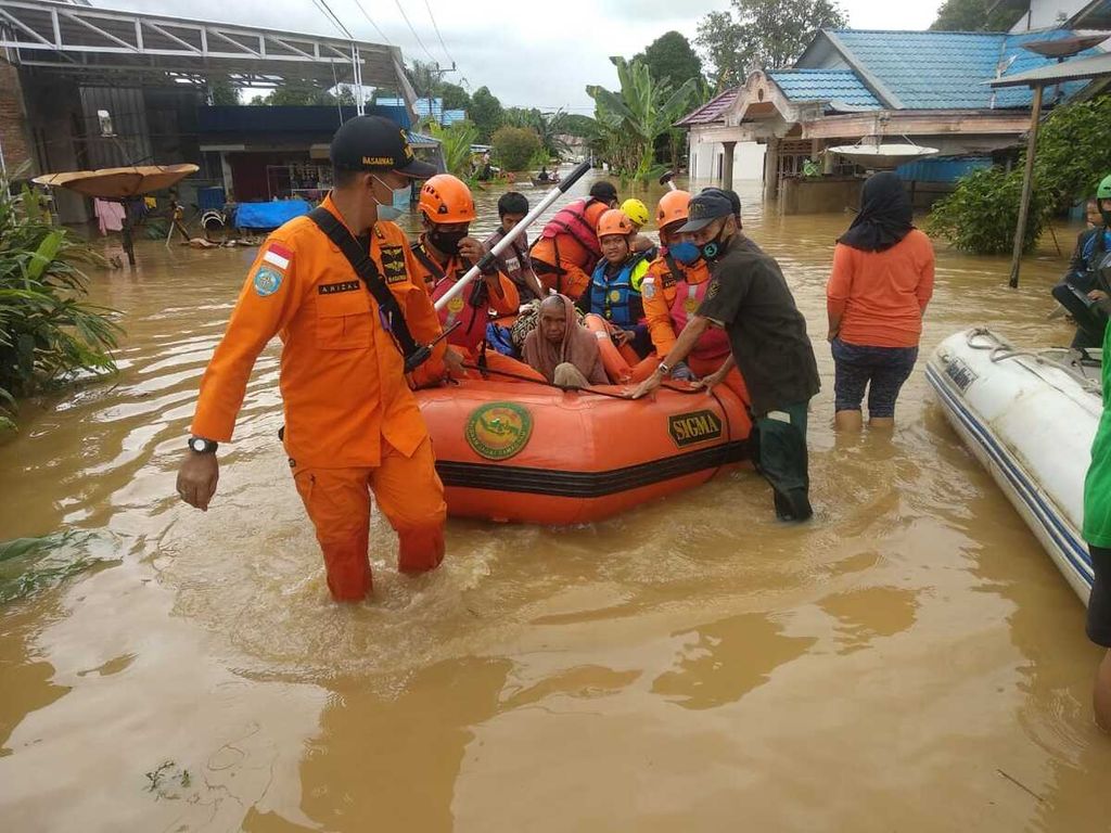
BASARNAS BANJARMASIN
Banjarmasin SAR members evacuated flood victims in Pengaron District, Banjar Regency, South Kalimantan, on Tuesday (12/1/2021).
The ecological factors that triggered the big floods in South Kalimantan are reflected in the current environmental damage. The Jatam mining advocacy network notes that there are 814 mine pits in South Kalimantan, some of which are still in operation and other that have been abandoned. In addition, 700 ha of mining land overlaps with residential areas, 251,000 ha of mining land is located in agricultural areas, and 464,000 ha of mining land lies in designated forest areas.
One of the mine pits is found in the upper reaches of the Martapura River, a tributary of the Barito River. According to Kompas monitoring over the last few days, a lot of former mining areas were abandoned in Banjar regency, such as in the villages of Pengaron, Lubang Baru, Maniapun in Pengaron district and in Simpang Empat village in Simpang Empat district.
The executive director of the Indonesian Forum for the Environment (Walhi) of South Kalimantan, Kisworo Dwi Cahyono, said that, while the upstream area was used for mining, the downstream area, which mostly comprised of peat hydrological area, was slowly converted into oil palm plantations, such as those in Tapin regency, South Kalimantan, which is also the upstream of the Barito and Martapura rivers.
Time for improvement
Coordinating Human Development and Culture Minister Muhadjir Effendy said Thursday (21/1) that he hoped the floods in South Kalimantan would be used as an opportunity to better manage the environment. "This is the time to make radical corrections to environmental and land use planning, because disasters start from unwise land management," he said.
"Kalimantan with its [resource] wealth is indeed the target of many people. Do not let wealth be extracted for the benefit of certain groups of people and have a bad impact on the community as whole,” he said.
The head of the South Kalimantan Environment Agency, Hanifah Dwi Nirwana, said an in-depth study was currently being carried out to determine the factors causing the flooding, which could be used to find solutions in the future. "All elements and components can work together so that in the future there will not be a disaster as bad as today," he said. (JUM/IDO/AIK/MTK)
(This article was translated byHendarsyah Tarmizi).