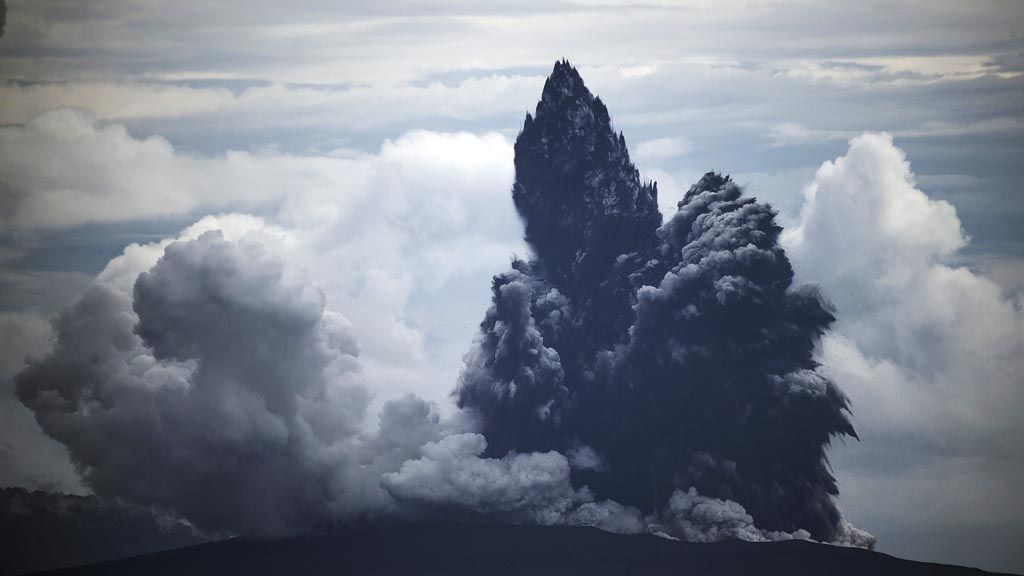
The Mount Anak Krakatau eruption is seen from the KRI Torani 860 Navy vessel while sailing in the Sunda Strait, Lampung, Tuesday (1/1/2019). The Center for Volcanology and Geological Disaster Mitigation said that the status of Mount Anak Krakatau was still at level III (alert).
JAKARTA, KOMPAS -- The surface of Mt. Anak Krakatau is constantly changing following the landslide that triggered the tsunami on Dec. 22. Eruptions and landslides persist, but no subsequent tsunami has been recorded. Earthquakes in the Sunda Strait are another potential source of tsunamis.
“Analysis of satellite images up to Dec. 31 at 6:23 p.m. shows that the surface [of the mountain] has changed,” Agency for the Assessment and Application of Technology (BPPT) researcher Agustan said in Jakarta on Tuesday (1/1/2019).
Geology Agency head Rudy Suhendar said Mt. Anak Krakatau had repeatedly erupted since Dec. 24, as heard from the Pasauran post in Carita, Banten. A large eruption occurred on Dec. 26-27, after which the top of the mountain, which was formed in 1950, collapsed. Due to this eruption, Mt. Anak Krakatau’s height was reduced from 338 meters to 110 meters above sea level.
After the eruption, volcanic activity decreased. “Based on seismic and visual data evaluation, the potential for further tsunamis from the activity of Mt. Anak Krakatau is very small,” Rudy said.
Earthquake
BPPT tsunami expert Widjo Kongko said volcanic activity was not the only potential source of tsunami in the Sunda Strait. Tsunamis may also be triggered by earthquakes in the subduction zones at the Sunda Strait segment. “I have issued plenty of warnings, but many have refuted me. The police even wanted to question me,” he said.
In line with the National Earthquake Source and Hazard Map issued by the Public Works and Housing Ministry in September 2017, there is a potential for earthquakes of a magnitude of 8.7 from the megathrust zone in the Sunda Strait segment. In 1903, a 8.1-magnitude earthquake was recorded in this segment.
Based on the 2017 earthquake map, Widjo said he had created a tsunami model to measure the potential height of a tsunami and how long it would take for a tsunami to reach land.
Widjo revealed his findings at a seminar at the Meteorology, Climatology and Geophysics Agency (BMKG) on April 3. Widjo created six tsunami scenarios, ranging from the smallest to the biggest.
In the worst-case scenario, an earthquake stronger than magnitude 9 may lead to an undersea collapse of more than 1,000 kilometers long and a 57-meter-high tsunami in Pandeglang, Banten. “This is the worst-case scenario. It is not a prediction, but it could happen based on the model. In mitigation, we need to calculate various scenarios,” Widjo said.
Based on the model, a 10-meter-high tsunami could hit the Cilegon industrial region, thereby triggering an industrial disaster.
“We do not know when an earthquake may strike. However, based on a number of studies, the earthquake zones in this region remain locked and the potential exists. In the future, there must be evaluations on better spatial planning and mitigation scenarios,” Widjo said.
Meanwhile, a number of tsunami survivors in Pandeglang have begun to return to their homes from emergency shelters as they said that they felt it was safe to do so. Nevertheless, many others chose to stay at shelters as their houses had collapsed and they were afraid of further tsunamis. Locals are hoping to receive disaster aid from the government.
Pesanggrahan shelter coordinator Asep Saepudin said the number of displaced persons at the shelter had decreased. “Some of them have returned home. I think the number of displaced has decreased by about 40 percent,” Asep said.