Gunung Ruang Island Tsunami History and the Risks in the Future
Ruang volcanic island in North Sulawesi has a history of eruptions accompanied by tsunamis and this could happen again in the future.
This article has been translated using AI. See Original .
About AI Translated Article
Please note that this article was automatically translated using Microsoft Azure AI, Open AI, and Google Translation AI. We cannot ensure that the entire content is translated accurately. If you spot any errors or inconsistencies, contact us at hotline@kompas.id, and we'll make every effort to address them. Thank you for your understanding.
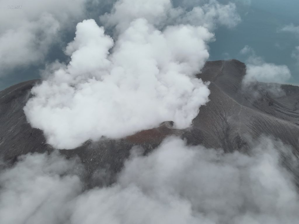
A picture of Mount Ruang in the Kepulauan Sitaro Regency, North Sulawesi, which erupted on Friday (19/4/2024). As a result of the eruption, the Sam Ratulangi Airport remains closed.
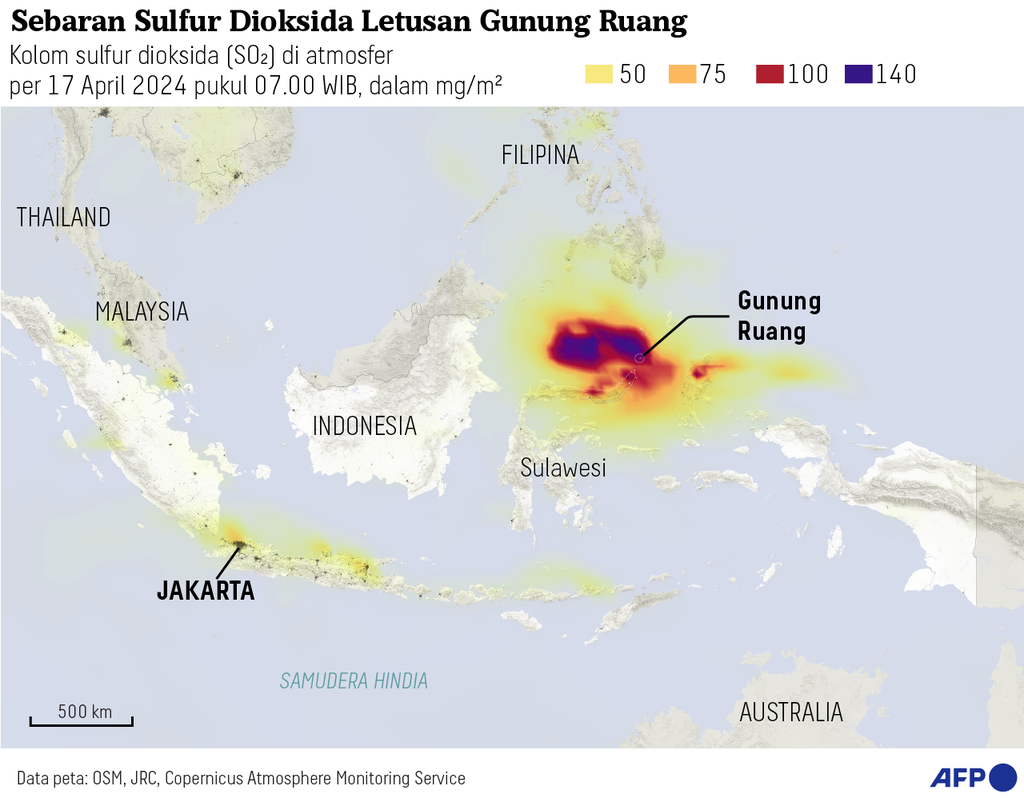
The volcanic island of Ruang in Sitaro Regency, North Sulawesi, has erupted again, triggering the evacuation of residents on surrounding islands. In addition to the threat of its explosive eruption characteristics along with hot clouds, the landslides of this volcano during the March 1971 eruption once triggered a large tsunami that killed at least 400 people.
This testimony regarding the enormity of the tsunami triggered by the eruption of Mountain Space was reported by German zoologist and anthropologist, Adolf Bernhard Meyer, in the book Ornithological Miscellany (1877). “I witnessed, in 1871, on Ruang Island, near Tagulanda, a terrible volcanic eruption,” said Meyer.
According to Meyer, before the eruption that occurred on March 3, 1871, the Ruang volcanic island was uninhabited. However, many plantations owned by residents from its neighboring island, Tagulandang, were located on its slopes.
"All of this was destroyed in just a few minutes due to the eruption; and the sea waves, as a result of the simultaneous earthquake (with the eruption), swept away the large village in Tagulandang, across from Ruang," said Meyer.
Also read: Mountain Space Still Erupting, Flights to Manado Paralyzed
SL Soloviev and Ch N Go note in the Catalogue of Tsunamis on the Western Shore of the Pacific Ocean (1984), the eruption of the Ruang volcano in 1871 was followed by strong ground shaking and was felt as far away as Tagulandang.
Along with that, the southern and western coasts of Tagulandang Island were submerged by sea waves or tsunamis that reached the land as far as approximately 180 meters with a height of 25 meters in Haas Village. At least 400 people died as a result of the disaster at that time.
All of this was destroyed in a matter of minutes due to the eruption, and the tsunami as a result of the earthquake that occurred simultaneously (with the eruption) swept through the large village of Tagulandang, across from Ruang.
Tsunamis triggered by volcanic eruptions, also known as volcanic tsunamis, have repeatedly occurred in Indonesia, especially on volcanic islands. There are several mechanisms that can trigger a volcanic tsunami, including the entry of pyroclastic flows into the ocean, strong underwater explosions, caldera collapse, and mountain slope landslides (flank collapse).
Among these various mechanisms, flank collapse which occurs during eruption is considered to be one of the most dangerous in generating volcanic tsunamis for volcanic islands.
Ignatius R Pranantyo, Mohammad Heidarzadeh, and Phil R Cummins in their publication in the journal Geoscience Letters (2021) have modeled a 25 meter tsunami from the eruption of Mount Ruang with a flank collapse mechanism.
Based on their conclusion, the 25-meter high tsunami observed in Haas Village was triggered by the collapse of part of the mountain into the sea with a volume of about 0.1 cubic kilometers. According to this scenario, the tsunami height along the south and west coasts of Tagulandang could reach 15 to 25 meters.
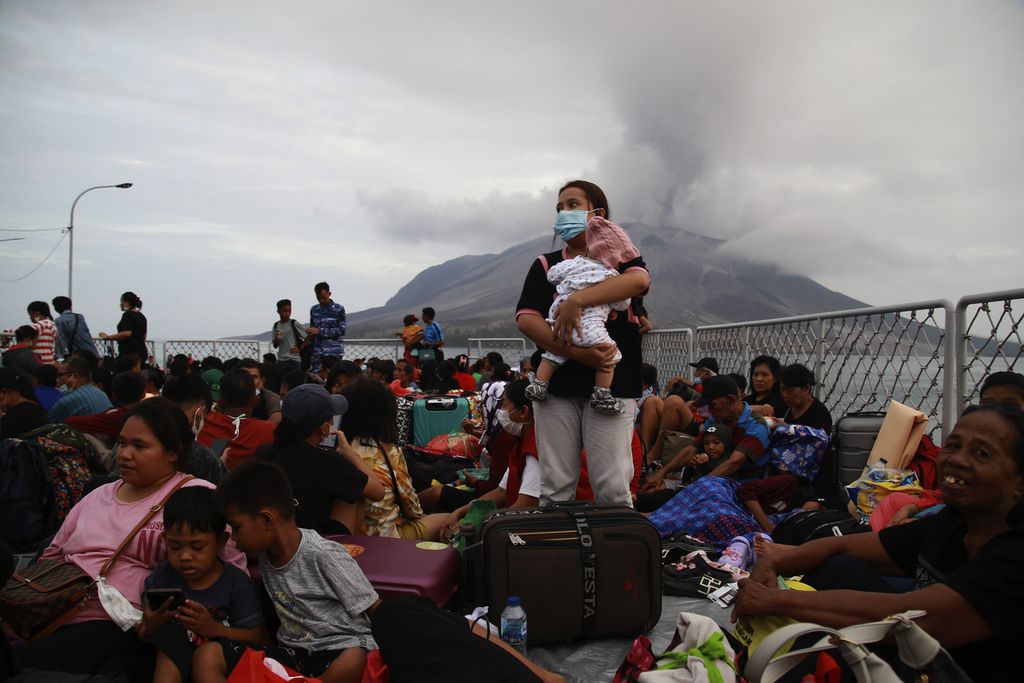
A resident carries their child on the deck of KRI Kakap-811 during evacuation at Tagulandang Port, Sitaro Islands Regency, North Sulawesi, on Wednesday (1/5/2024). The Navy's Danlantamal VIII evacuated around 330 people affected by the eruption of Mount Ruang using KRI Kakap-811 heading to Bitung Port due to the mountain's activity reaching Level IV Awas status.
Risk of recurrence
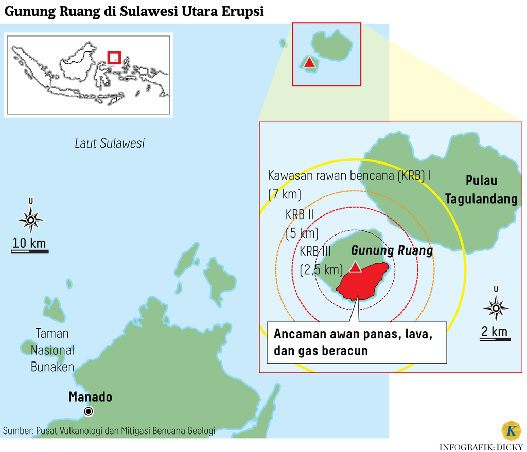
With a history of a volcanic tsunami in 1871, the government attempted to evacuate thousands of residents of Tagulandang Island within a radius of 7 kilometers from the center of the Ruang eruption, as recommended by the Center for Volcanology and Geological Disaster Mitigation (PVMBG). This evacuation process has been carried out in stages since April 30 2024 using a fleet of ships.
The Head of the National Disaster Management Agency (BNPB) Suharyanto stated during a Coordination Meeting on Handling the Mount Ruang Volcanic Eruption in Manado on Thursday (2/5/2024), that at least 3,364 residents have been evacuated from Tagulandang Island. Another 5,719 people are still in the process of being evacuated gradually.
"At least nine thousand residents within a 7-kilometer radius should be evacuated immediately," said Suharyanto. The government not only plans for temporary evacuation, but also intends to take permanent steps to relocate residents' settlements, especially those located on Ruang Island, the main island of the volcano, to safer locations.
Head of PVMBG, Hendra Gunawan, supports the plan to evacuate the danger zone of Mount Ruang, which has a height of 725 meters above sea level (masl). This is because historically, Ruang has often emitted hot clouds that directly impact life.
"It turns out that based on its history, Mount Ruang is indeed very prone to emitting hot clouds. So, it is appropriate that this is a dangerous area," said Hendra.
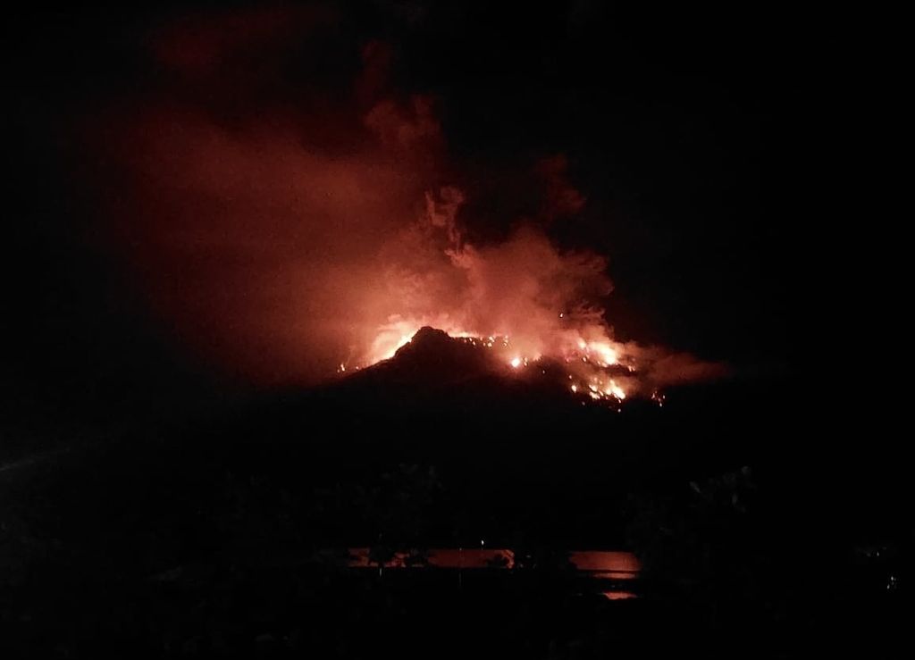
The eruption of Mount Ruang in the Siau Tagulandang Biaro Islands district (Sitaro) in North Sulawesi occurred on Tuesday (16/4/2024) evening. Hundreds of residents were evacuated.
Based on PVMBG's records, Mount Ruang has erupted repeatedly with intervals of approximately 30 years, including in 1808, 1810, 1840, 1856, 1870, 1871, 1874, 1889, 1904-1905, 1914, 1915, 1918, 1940, 1946, 1949, 2002, and 2024.
The last eruption before the 2024 event, which occurred in 2002, was an explosive eruption accompanied by pyroclastic flows that resulted in damage to land and settlements, as well as triggering the evacuation of residents.
Among the series of events, only the 1871 eruption is recorded to have triggered a tsunami wave. Tsunami expert from the National Research and Innovation Agency (BRIN), Widjo Kongko, stated that historically, volcanic tsunamis triggered by Mount Ruang have only occurred once.
Also read: Mount Ruang Eruption, 1,945 Residents Evacuated from Tagulandang Island
Despite this, the history of volcanic eruptions in our country is relatively short, dating back to the arrival of the Dutch colonial government. Therefore, it is very possible that data on previous eruptions, including the possibility of a tsunami before 1871, is unknown.
Empirically, volcanic tsunamis have occurred repeatedly on other volcano islands in Indonesia, with the majority occurring in eastern Indonesia.
Several volcanic tsunamis that have occurred include the eruption of Mount Rokatinda on Flores Island in 1928; Awu Island in 1856 and 1892, Gamkonora Island in 1673, and Gamalama Island in 1871, in addition to Tambora in 1815.
Lessons from Children of Krakatoa
One of the volcanic tsunamis that is still fresh in memory is the eruption of Anak Krakatau in 2018, which occurred without any warning. Prior to the tsunami, Anak Krakatau had been erupting for about six months, but the threat of the tsunami was underestimated.
Although the Krakatoa eruption was previously recorded to have caused a massive tsunami on August 27, 1883, which resulted in the deaths of more than 36,000 people, the risk of a tsunami from the eruption of Anak Krakatau is considered low due to the mountain's small volume at the time. However, the Anak Krakatau eruption on December 22, 2018 triggered a devastating tsunami, which inundated the coastlines of Java and Sumatra and claimed the lives of 437 people.
A collaborative research report from researchers from the Bandung Institute of Technology (ITB) with the University of Birmingham in the journal Earth and Planetary Science Letters in 2022 found that the Anak Krakatau tsunami in December 2018 was caused by a long-term destabilization process of the mountain body and was not triggered by changes. in magmatic systems.
This causes the incident to not be detected by the volcano monitoring system, thus requiring a change in risk mitigation strategy moving forward.
Also read: Awas Space Mountain, 6 Kilometer Radius from the Top of the Forbidden Area
Sebastian Watt, a geologist from the University of Birmingham who was the main author of the study, stated that this type of volcanic tsunami danger is rare, very difficult to predict, and often devastating.
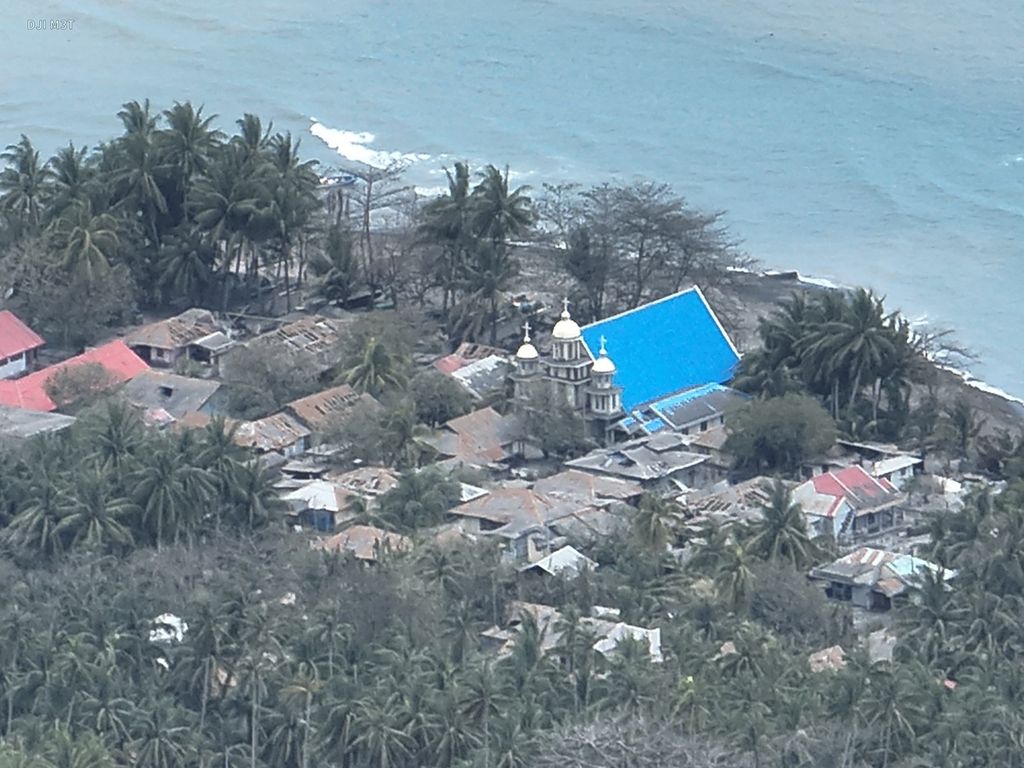
The condition of Tagulandang Island in the Sitaro Islands Regency, North Sulawesi, which was recorded on Friday (18/4/2014). Thousands of residents fled and secured themselves independently due to the eruption of Mount Ruang.
"Our findings show that, despite the dramatic explosive eruptions following the collapse of Anak Krakatau, this was triggered by a landslide that released pressure on the magma system - like a champagne cork popping," he wrote.
This situation presents a challenge for predicting hazards on volcanic islands in the future. Large volcanic landslides occur due to long-term instability and can happen without any significant changes in volcanic activity. This is what causes volcanic tsunamis to suddenly and unpredictably occur without clear warnings.
With a history of deadly volcanic tsunamis, we need to anticipate the worst risks by evacuating residents around the Ruang volcano island currently....