More than 11,000 people need to be evacuated due to the eruption of Mount Ruang
More than 11,000 residents need to be evacuated to avoid the impact of the eruption of Mount Ruang in North Sulawesi.
This article has been translated using AI. See Original .
About AI Translated Article
Please note that this article was automatically translated using Microsoft Azure AI, Open AI, and Google Translation AI. We cannot ensure that the entire content is translated accurately. If you spot any errors or inconsistencies, contact us at hotline@kompas.id, and we'll make every effort to address them. Thank you for your understanding.
By
PRADIPTA PANDU
·4 minutes read
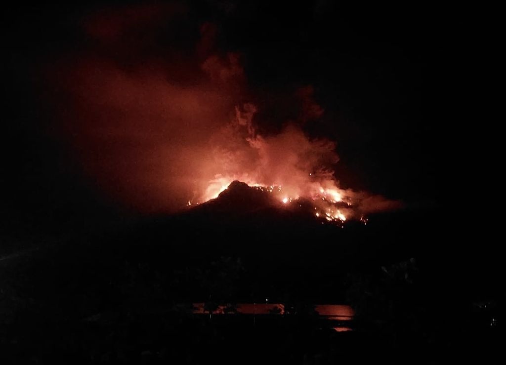
DOKUMENTASI BPBD SITARO
The eruption of Mount Ruang in the Kepulauan Siau Tagulandang Biaro (Sitaro) Regency in North Sulawesi occurred on Tuesday night (16/4/2024). Hundreds of residents were evacuated.
JAKARTA, KOMPAS — To date 828 residents have been evacuated following the Mount Ruang eruption in the Siau Islands Regency, Tagulandang Biaro or Sitaro, North Sulawesi, on Wednesday (17/4/2024) evening . However, from calculations, it is estimated that more than 11,000 people need to be evacuated to avoid the impact of the eruption.
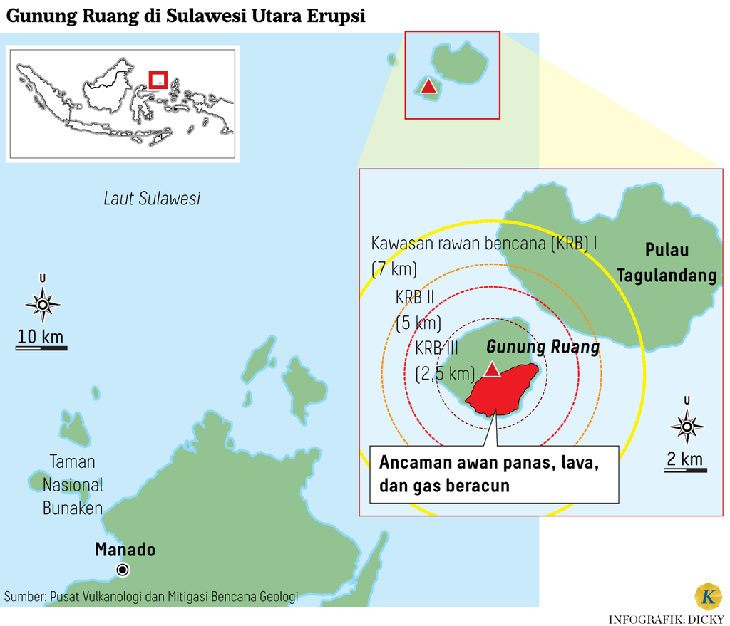
The Center for Volcanology and Geological Disaster Mitigation (PVMBG) has raised the alert level of Mount Ruang from "Watch" to "Warning" as of April 17, 2024 at 9:00 PM Wita. This is due to a significant increase in visual activity and seismicity at Mount Ruang.
The Head of the Data, Information and Communication Center for Disaster Management at the National Disaster Management Agency (BNPB), Abdul Muhari, stated that the increase in the Alert status or level IV has implications in terms of emergency response. The impact of this status increase is that there should not be any activities within a 6-kilometer radius of Mount Ruang.
"This implies that the area must be evacuated as soon as possible. Evacuating the area at night will certainly face many challenges and obstacles," he said in a virtual press conference, early Thursday morning on April 18, 2024.
In order to prevent a worse impact from the eruption, until now the local government and the Regional Disaster Management Agency (BPBD) of Sitaro Regency have evacuated around 828 residents, consisting of 506 residents from Laingpatehi Village and 322 residents from Pumpente Village.
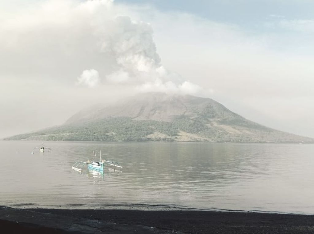
DOKUMENTASI BPBD SITARO
The condition of Mount Ruang in the district of Kepulauan Siau Tagulandang Biaro (Sitaro) in North Sulawesi, which erupted volcanic ash rain on Wednesday (17/4/2024).
Meanwhile, according to the calculations from the INARisk application, the potential number of residents affected in high-risk areas or within a radius of 2.5 km reaches 1,585 people. Then, in the medium-risk class (within a radius of 4 km), it is 6 people, and the low risk (within a radius of 7 km) reaches 10,024 people.
"The static population count of residents in the location should be at least 11,000 people who need to evacuate temporarily. However, due to the nighttime situation, BPBD cannot directly identify them. Until now, the BNPB has also not received any reports of injured victims due to the lava stone throw," said Abdul.
This has implications that the area must be evacuated as soon as possible. Evacuation of the area at night will certainly encounter many challenges and obstacles.
According to reports, on Wednesday night, Mount Ruang still spewed glowing rocks that reached the homes of residents even though they were already outside the 6 km radius. Therefore, residents continue to make independent efforts to evacuate, such as climbing the hill areas by foot or using vehicle routes to the northeast and north regions.
As part of efforts to accelerate the handling of COVID-19, the Regent of the Sitaro Islands has established a State of Emergency through Decree Number 100 of 2024 for a period of 14 days from April 16-29, 2024. The emergency response period is dynamic and can be extended in accordance with regulations based on conditions in the field.
Earthquake activity
PVMBG Head of Geological Agency, Hendra Gunawan, stated that there were 400 volcanic earthquakes detected in Mount Ruang on Wednesday morning (17/4/2024). Then, several eruptions occurred from noon until Wednesday night, with a height reaching 3 kilometers in the form of lava bursts or hot clouds.
In addition to geological activity, Hendra highlights the history of the eruption of Mount Ruang, which is quite complicated because there is no definite gap and always changes. However, the nature of the eruption of Mount Ruang has been recorded as explosive, heat-resistant, and triggers tsunamis since ancient times.
"In its history, the eruption of Mount Ruang has claimed many victims due to the eruption itself or the impact of a tsunami. This is what needs to be emphasized, so the community, especially those on the west coast of Tagulandang Island, need to be evacuated to avoid the impact of a tsunami or hot ash cloud," he said.
Based on PVMBG's instrumental record, on Tuesday (16/4/2024) at 9:45 pm Wita, Mount Ruang experienced an explosive eruption with an estimated column height of 2,000 meters from the peak. The condition continued to escalate until the ash column reached 2,500 meters from the peak on Wednesday (17/4/2024) at 1:08 am Wita.
Then, on Wednesday night at 21:15 WITA, another explosive eruption occurred with a gray to black ash column reaching a height of approximately 3,000 meters, accompanied by a roaring sound and felt earthquake at the Mount Ruang Volcano Observation Post.
Editor:
EVY RACHMAWATI
Share
Kantor Redaksi
Menara Kompas Lantai 5, Jalan Palmerah Selatan 21, Jakarta Pusat, DKI Jakarta, Indonesia, 10270.
Tlp.
+6221 5347 710
+6221 5347 720
+6221 5347 730
+6221 530 2200
Kantor Iklan
Menara Kompas Lantai 2, Jalan Palmerah Selatan 21, Jakarta Pusat, DKI Jakarta, Indonesia, 10270.