Java’s Forgotten Shallow Earthquakes
A devastating earthquake originating from an inland source occurred near the Central Java city of Wonosobo in 1924. This quake caused mudslides and killed almost 900 people.
Data indicate that shallow earthquakes more powerful than the recent Cianjur quake could occur in more densely populated cities on the island of Java.
The recent 5.6-magnitude shallow earthquake that struck Cianjur, West Java, points to the dangers of shallow crustal earthquakes on the densely populated island of Java. Records from the colonial era show that shallow earthquakes devastated a number of cities on Java, including Cianjur in 1879, Cirebon in 1847 and Wonosobo in 1924.
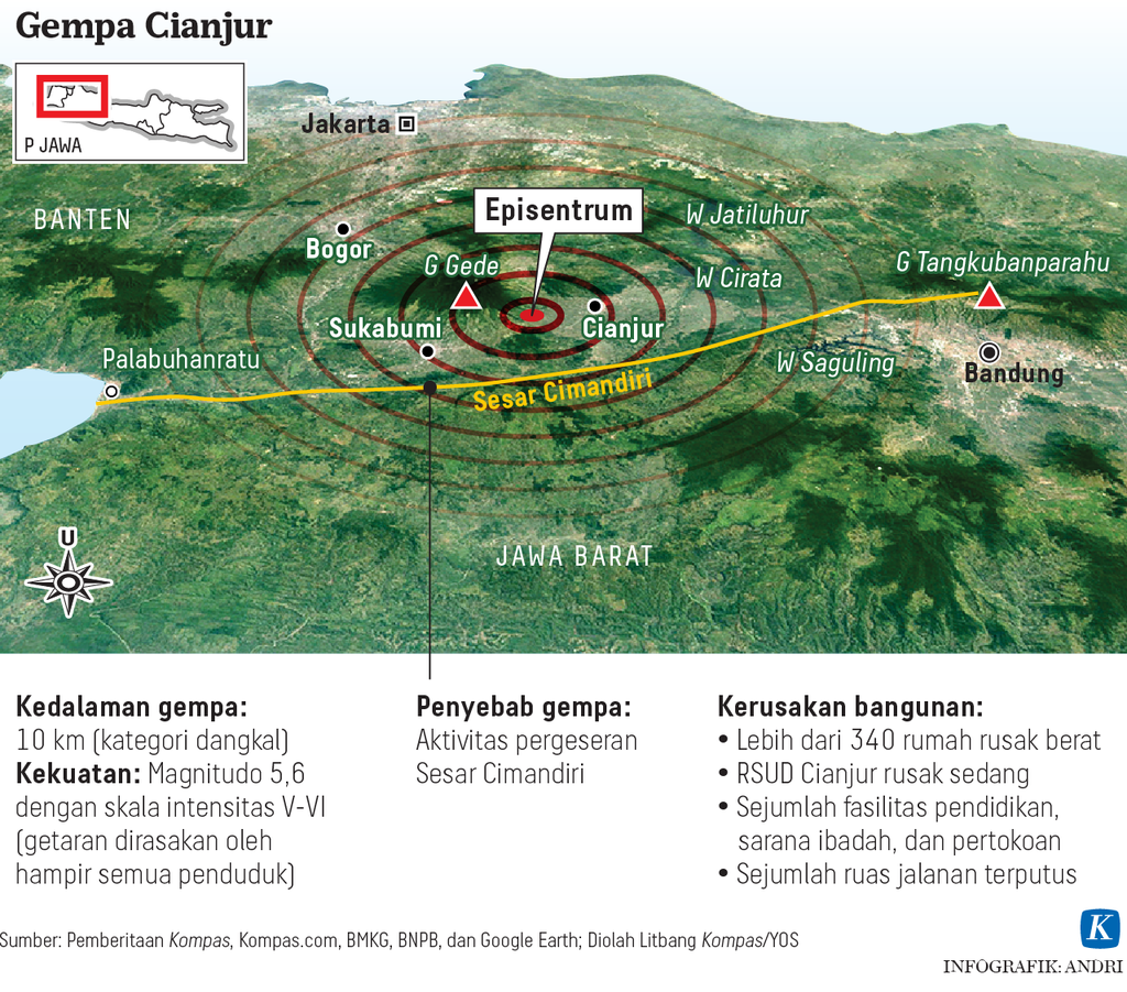
The recent Cianjur quake demonstrates that a shallow earthquake of low magnitude can cause enormous destruction. According to the National Disaster Mitigation Agency (BNPB), 323 people were killed and 9 others still missing as of Monday (28/11/2022).
The head of the Earthquake and Tsunami Center of the Meteorology, Climatology and Geophysics Agency (BMKG), Daryono, explained that the Cianjur quake was highly destructive for several reasons, including its very shallow hypocenter, its epicenter’s close proximity to human settlements, the settlements’ location in an area with soft earth and local site effects, and the settlements’ location in a hilly area with topographic site effects.
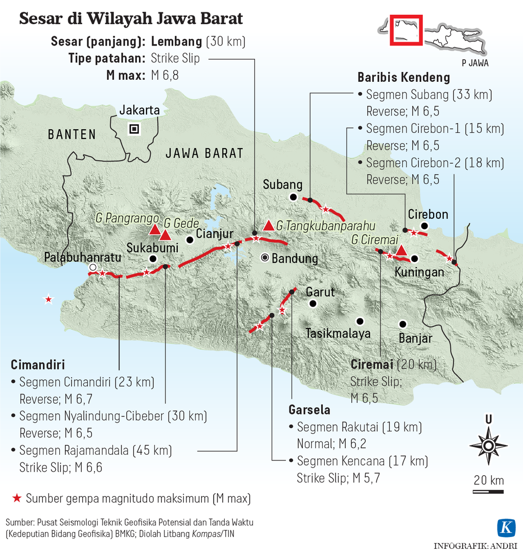
The most significant factor was that local buildings did not meet quake-proof standards. Although the quake originated on the Cimandiri sinistral strike-slip fault that triggered high-intensity ground movement of MMI (Modified Mercalli Intensity) VII, if the buildings had met quake-proof standards, they would have withstood the seismic shock. Quake-proof structures are capable of withstanding tremorsof up to MMI IX.
Also read:
> Earthquake Zone and Earthquake Resistant Houses
> Prioritizing Evacuation and Shelters
Learning from the Cianjur quake, we need to anticipate the threat of shallow crustal earthquakes originating along inland faults. Despite their low magnitude, earthquakes of this type can be dangerous if they strike densely populated regions, like those in Java.
“Gempa Nusantara: A Database of 7,380 Macroseismic Observations for 1,200 Historical Earthquakes in Indonesia from 1546 to 1950”, written by Stacey S. Martin, Phil R. Cummins and Aron J. Meltzner and published in the Bulletin of the Seismological Society of America in October 2022, covers the many destructive earthquakes that have struck Java since the 17th century.
“Nine earthquakes since 1865 have caused shaking so severe they were almost certainly shallow events,” writes Prof. Cummins, an earthquake expert from the Australian National University, and his team (The Conversation, 2022).
An eyewitness described being thrown off a chair and a herd of cows being knocked off their feet.
A devastating earthquake originating from an inland source occurred near the Central Java city of Wonosobo in 1924. This quake caused mudslides and killed almost 900 people. Cummins and his team also documented extremely violent seismic waves that resulted from the 25 Oct. 1875 earthquake near Kuningan, West Java. An eyewitness described being thrown off a chair and a herd of cows being knocked off their feet.
The next was Cianjur, the site of last week’s earthquake, which had experienced a damaging earthquake on 28 March 1879 that caused the several buildings to collapse with several lives lost.
Cirebon experienced a damaging earthquake on 16 Nov. 1847 that caused a river to deviate 5 meters from its original path, suggesting a magnitude of 7 or greater. This violent tremor is also confirmed in a report by Mudrik Rahmawan Daryono and his team from the National Research and Innovation Agency (BRIN) in the IOP Conference Series: Earth and Environmental Science (2021).
According to Mudrik, the 1847 Cirebon quake was triggered by the Baribis Fault, proving that the fault line extending to the southern part of Jakarta was active. The Baribis Fault was verified by previous researches, including the study by Simandjuntak and Barber (1996), but its active status was debated.
Using geological mapping with seismic reflection data, Achraf Koulali and his team (2017) discovered that the Baribis Fault, a strike-slip fault located 25 kilometers south of Jakarta, was active with a slip rate of around 5 millimeters per year.
The latest report from Sri Widiyantoro and his team at the Bandung Institute of Technology in Scientific Reports (2022) proved that the western part of the fault line was locked. Consequently, southern Jakarta is vulnerable to an earthquake caused when the accumulated strain energy is released.
Although historical records on the Lembang Fault are limited, Mudrik Daryono and his team have mapped geological evidence of prehistoric earthquake activities. This fault is estimated to cause tremors of magnitude 6.5-7.0 every 170-670 years.
Historical data show that Jakarta and the surrounding area were once hit by a strong and destructive quake. Research by Nguyen and team (2015) discovered that the tremor that devastated Jakarta on 22 Jan. 1780 originated on the Baribis Fault and had a magnitude of 7-8, followed by a second tremor with a magnitude of 7-7.7 on 10 Oct. 1834. The inland quake triggered powerful ground shaking.
Besides the Baribis and Cimandiri faults, West Java also has the Lembang Fault that lies just outside the city of Bandung, which has a population of 8.8 million people. Although historical records on the Lembang Fault are limited, Mudrik Daryono and his team have mapped geological evidence of prehistoric earthquake activities. This fault is estimated to cause tremors of magnitude 6.5-7.0 every 170-670 years.
East Java
An active fault is also found in the eastern part of Java. On Thursday (11/10/2018), a 6-magnitude quake struck the East Java regencies of Situbondo and Sumenep. The BMKG identified the tremors as having a south-dipping thrust that originated in the Flores Thrust.
The Flores Thrust connects to the active Kendeng Fault. According to National Earthquake Sources 2017, the Kendeng Fault extends westward and eastward across Central Java to as far as East Java. In the west, the Kendeng Fault links up with the Semarang Fault and with the Baribis Fault further west.
Earthquake researcher Gayatri Indah Marliyani from Gadjah Mada University, in her dissertation on tectonic faults in Java, refers to recurrent tremor of magnitude 6-7 in several locations that can cause massive destruction like the 2006 earthquake in Yogyakarta.
Colonial-era documents revealed that on 26 Nov. 1852, an earthquake occurred with damage concentrated in Grati, Pasuruan, East Java. The tremor was felt as far as Surabaya, 60 kilometers away. A note by Visser S.W. (1922) listed 21 strong tremors that occurred in Java in 1699-1920. Their epicenters were located in Cirebon, Rembang, Banyumas, Yogyakarta, Kuningan, Cianjur, Madiun, Salatiga and other regions.
The historical and geological evidence point to earthquakes as a fact of life in Java. Shallow earthquakes more powerful than the Cianjur quake could happen in more densely populated cities.
Earthquakes cannot be predicted as yet. It’s only a matter of time that the disaster will again strike densely populated cities in Java. Reducing the risk of disaster should ideally start with spatial planning and design that avoids active fault lines.
Analysis in 2019 by a team from the National Earthquake Study Center (Pusgen) pointed out that the United States in 1977 set safe distances from main faults at 150 meters and from branch faults at 60 meters. In Taiwan, if a fault has a history of generating tremors of magnitude 7 or greater, the safe distance is 100 meters on both sides. For faults with a history of generating tremors of less than magnitude 6, the safe distance is 30 meters.
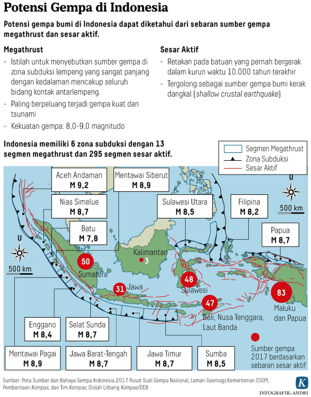
Removing buildings from fault zones in Indonesia is not simple. Referring to the map of National Earthquake Sources 2017, the Pusgen research team estimates that 4 million people and 2,892 schools in the country are located in earthquake hazard zones within a radius of 1 kilometers from faults.
At least the construction of new buildings should not be permitted on or near faults. This means that regional administrations must take the initiative to integrate their spatial plans with earthquake hazard maps. Existing buildings should be reinforced to make them earthquake-resistant.
We can also use the model of the Japanese government, which provides subsidies to people to reinforce their houses in line with quake-proof standards. Reinforcing people’s houses should be seen as investment for reducing the risk of earthquakes.
This article was translated by Aris Prawira.