Earthquake, Policy and Literacy Based on Science
Studies on subduction-zone earthquakes, especially the phenomenon of the tsunami-generating megathrust earthquake, were carried out intensively in response to the 2004 Boxing Day earthquake and tsunami.
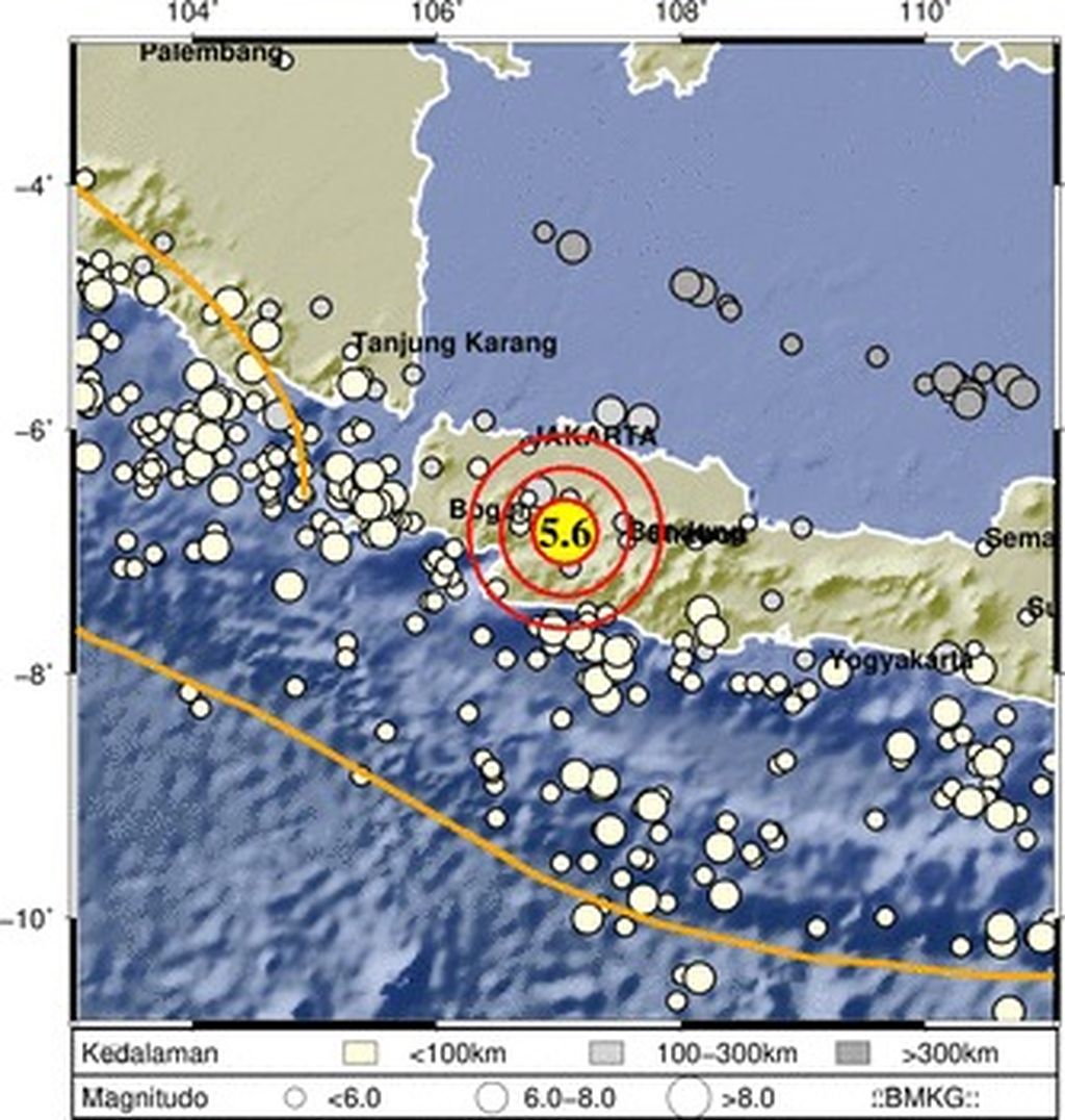
On Monday, 21 November 2022, 1:21 p.m. WIB, the island of Java was again shaken by an earthquake, with the epicenter only 10 kilometers from Cianjur regency, West Java.
The official website of the Meteorology, Climatology and Geophysics Agency (BMKG) reported an earthquake measuring 5.6 M centered at 6.84 south latitude, 107.05 east longitude at a depth of 10 km. At the time this article was written, the National Disaster Management Agency (BNPB) recorded that 271 people died, 40 people were being sought for, 2,043 were injured and around 61,000 people were displaced.
The impact of the earthquake was felt by 12 districts in West Java. The strength of the Cianjur earthquake, which was classified as moderate, but claimed many lives and caused quite heavy damage, certainly raises questions in the minds of the public. Why did this region experience such a devastating result from an earthquake? Can we know the potential impact of an earthquake in the area where we live?
Tectonic structure and risk of the Sunda Arc earthquake
Sumatra and Java are two large islands in the Sunda Arc, which are known to be tectonically active. The study of earthquake hazards in the Sunda Arc has attracted the attention of researchers for a long time.
Studies on subduction-zone earthquakes, especially the phenomenon of the tsunami-generating megathrust earthquake, were carried out intensively in response to the 2004 Boxing Day earthquake and tsunami.
Also read:
> Almost Half of Quake Victims are Children
> Earthquake Zone and Earthquake Resistant Houses
In addition to Sumatra, the seismicity of the subduction zone and tsunami have also been studied intensively in Java, especially since the 27 July 2006 tsunamigenic earthquake that hit the coasts of Pangandaran, West Java, and Cilacap, Central Java, and claimed hundreds of lives. Due to this study of the earthquake and tsunami in Sumatra and Java, we have a reliable tsunami early-warning system as it is now.
As an archipelagic country where three main plates interact — Eurasia in the northwest, Indoaustralia in the south and the Pacific in the east — the potential for earthquake hazards in Indonesia does not only come from subduction zones.
The widespread dissemination of the results of earthquake and tsunami studies in the subduction zone through scientific publications in well-known journals and via forums that involve the general public has increased public literacy regarding the potential for disasters originating from the subduction-zone activities. As an archipelagic country where three main plates interact — Eurasia in the northwest, Indoaustralia in the south and the Pacific in the east — the potential for earthquake hazards in Indonesia does not only come from subduction zones.
Past-tectonic activity, together with the dynamics of the interaction of the three main plates today, have resulted in many tectonic and volcanic features in most of Indonesia. One of the tectonic features that are formed and should be watched out for is shallow-crust faults or faults in the earth's crust.
This kind of fault has a potential impact that is no less terrible than a megathrust earthquake. The shallowness of the earthquake source and its location on the mainland make the distance between the earthquake source and the infrastructure built by humans negligible.
The local geological conditions where the building stands and the lack of understanding of earthquake-resistant buildings are also factors that affect the impact of the earthquake. The combination of all of the above factors makes the earthquake caused by this shallow fault seem to be a life-killing machine that lurks at any moment in a densely populated country like Indonesia.
Between Yogyakarta 2006 and Cianjur 2022
The Cianjur earthquake phenomenon is actually not a new thing for Indonesia. Some of us will remember the earthquake that shook Yogyakarta and parts of Central Java on Saturday morning, 27 May 27, 2006. The earthquake measuring M 6.3 was centered at 8.007° south latitude and 110.286° east longitude at a depth of 17 km, killing around 5,700 people. More than 100,000 houses and buildings collapsed or were damaged.
Deducing from the location of the epicenter and its depth, the 2006 Yogyakarta earthquake and the 2022 Cianjur earthquake were caused by a similar type of fault. The Yogyakarta earthquake was initially seen as originating from the Opak Fault because the most severe damage was along the Opak River, which has so far been described as the location of the fault in geological maps.
However, recordings of the aftershocks of the 2006 Yogyakarta earthquake show that the epicenter of the aftershock was in the Wonosari highlands, about 15 km east of the Opak River (Walter et al, 2007, Walter et al, 2008). The epicenter of the 2006 main earthquake, according to the United States Geological Survey (USGS), also indicated a position close to aftershocks.
As explained above, in addition to the strength of the earthquake and the distance between the earthquake source and the area that felt the vibrations, there are other factors, namely the local geological conditions of the area.
This finding gives rise to a new understanding of the location of the fault that caused the Yogyakarta earthquake and demands an explanation for the discrepancy between the location of the source of the earthquake and the area that suffered severe damage. As explained above, in addition to the strength of the earthquake and the distance between the earthquake source and the area that felt the vibrations, there are other factors, namely the local geological conditions of the area.
In the case of the Yogyakarta earthquake, the thickness of the sediment and the physical properties of the sedimentary material that are not compact along the damage zone cause amplification when the earthquake waves shake the zone. Strong ground shaking toppled poor-quality buildings and killed their occupants.
What about the Cianjur earthquake? Several parties indicated that this earthquake was caused by the movement of one segment of the Cimandiri Fault. The Cimandiri Fault itself stretches from Sukabumi, West Java, across Cianjur regency until it stops in the northwest of Bandung regency, West Java. Since 2009, several earthquakes have occurred along the Cimandiri Fault, indicating that this fault is active.
Efforts to characterize the Cimandiri Fault have actually been made, starting from identifying the geometry of the fault segment with accurate seismicity-distribution mapping and imaging the fault-plane structure using seismic tomography. In addition to fault geometry, quantification of the speed and direction of shift of the active segment is also done through observation of Global Positioning System (GPS) data.

Apart from the publication of the results of the studies that have been made, the existence of settlements along the Cimandiri Fault is an undeniable fact. Ideally, the area along the active-fault zone would be forbidden to inhabit. The factor of the proximity of the building to the epicenter of the earthquake and the building-quality factor caused the high number of casualties and the number of buildings damaged by the earthquake last Monday.
Science-based policy and literacy
Back to the question at the beginning: can we know the potential impact of an earthquake around us and avoid the fatal effect? Efforts from a scientific perspective to determine the potential impact of shallow earthquakes in Indonesia have been made by researchers at research agencies, universities and related institutions. Unfortunately, the results of research and efforts from a scientific perspective have not been consistently adopted as the basis for policymaking and earthquake-mitigation literacy.
This is far different from the issue of the impact of climate change where the government and civil-society groups intensely echo the policy approach and science-based literacy. Meanwhile, the impact of earthquakes and other earth disasters is very real.
In fact, popularizing the scientific approach as the basis for public policy and literacy is not as difficult as imagined.
Science and topics such as earthquakes have been considered complicated for the general public to understand. In fact, popularizing the scientific approach as the basis for public policy and literacy is not as difficult as imagined.
For example, the earthquake shaking-intensity map (shakemap) from the BMKG can become a reference for the community to know the potential impact of an earthquake in their area. If there are startups that are interested in developing versions of popular applications that are easily accessible to the public, it would be very helpful for mitigation efforts.
Of course, we have homework to improve accuracy and resolution. However, the bigger question is to what extent do we consistently use scientific predictions in our policy? The basic need for regional spatial-planning policies and building standards is an example.
On the literacy side, disaster education does not only have to be via textbooks. School-age children in the Mount Merapi area, for example, learn to mitigate volcanoes via school extracurriculars.
In the current era of accessible digital information, there is plenty of room for disaster-science literacy in various formats and languages that are close to the community. If awareness of the importance of science underlies our commitment to live with natural phenomena that are an inseparable part of Indonesia, we can avoid catastrophic impacts like the ones in Cianjur.
Ade Anggraini, Lecturer for the department of Physics, faculty of Mathematics and Sciences, Gadjah Mada University
(This article was translated by Kurniawan Siswo)