Flores Sea Prone to Tsunamis
By realizing all the mitigation measures, we will be able to minimize the impacts of disasters so we can live safely and comfortably, even in disaster-prone areas.

Hardly had the news faded regarding the Mount Semeru eruption in East Java that claimed a number of lives, when we were surprised by a strong earthquake that struck the Flores Sea and the surrounding area.
The strong and shallow 7.4-magnitude earthquake occurred on Tuesday, 14 Dec. 2021 at 10:20:23 a.m. Western Indonesia Time (WIB).
An analysis by the Meteorology, Climatology and Geophysics Agency (BMKG) showed that the epicenter was located under the sea at coordinates 7.59 degrees South latitude (LS) and 122.24 degrees East longitude (BT), 112 kilometers northwest of Larantuka, East Nusa Tenggara, and at a depth of 10 km.
The earthquake was a shallow earthquake caused by a rupture in the active strike-slip fault in the Flores Sea.
The BMKG’s tsunami modeling study showed that the earthquake, rated a Waspada (advisory) alert level, had the potential to trigger a tsunami at an estimated height of below 50 cm in northern East Flores, Sikka Island, northern Sikka, and Lembata Island. The level of the hazard prompted the BMKG to issue a tsunami early warning for the Flores Sea and surrounding areas.
The tsunami early warning issued by the BMKG was confirmed by the tsunami that followed, although it was small. Using a tide gauge, the sea level monitoring and tsunami detection by the Geospatial Information Agency (BIG) showed a 7-centimeter rise in sea level at the Reo and Marapokot tide gauge station in East Nusa Tenggara. Because the tsunami that occurred did not have a significant impact, the tsunami early warning was lifted at 12:27 p.m. WIB.
Also read:
> East Java Earthquake, an Alarm for Us
> Natural Disasters and Our Systemic Vulnerability
We should be grateful that the 7.4-magnitude earthquake did not trigger a destructive tsunami. However, the earthquake, which had a Modified Mercalli Intensity (MMI) of 4-5, damaged hundreds of residential structures and injured several people in the Selayar Islands.
Following the earthquake, strong aftershocks of MMI 3-4 were felt in Ruteng, Labuan Bajo, Larantuka, Maumere, Adonara, and Lembata.
Unmapped fault lines
The strong and damaging earthquake in the Flores Sea is actually not an unusual occurrence, given the fact that the Flores Sea is tectonically located in an active and complex seismic zone.
The seismic source model used to develop the 2017 Indonesian spectral hazard map (Irsyam et al 2020) shows the tectonic complexity of the region.
The region has at least eight earthquake-generating active faults: the RMKS (Rembang, Madura, Kangean, Sakala) fault, the Lombok-Sumbawa thrust fault, the West Flores thrust fault, the Central
Flores thrust fault, the East Flores thrust fault, the Wetar thrust fault, the West Selayar fault, and the East Selayar fault.
An earthquake measuring 7.5 on the Richter scale was followed by tidal waves and hit as far as 300 meters inland, Saturday (12 December 1992) hitting the central and eastern parts of Flores Island, East Nusa Tenggara. Severe damage occurred in Kaputan Sikka (Maumere) and Ende District, and killed more than 1,000 people
What surprised geographers was that the epicenter of the shallow strike-slip 7.4-magnitude earthquake had occurred in a location that was not marked on the fault line map.
Interestingly, the epicenter was in an area with low seismic activity, according to 2009-2021 regional seismicity data. Although the epicenter of the earthquake was close to the Flores thrust fault, it had not been generated by the thrust fault.
The Flores seismic crust is characterized by a thrust fault, while the earthquake that occurred was discovered to be strike-slip. This means that the earthquake was triggered by an unmapped active fault.
Active fault lines are those that have experienced stress from the movement of tectonic plates in the last 10,000 years. So it is clear that the trigger of the recent earthquake was an active fault, but one that was discovered only after the earthquake had occurred.
Considering that the source of this earthquake was unmapped, it is a challenge for our geographers to identify and map the new fault to complement the existing map of earthquake sources and seismic hazards in Indonesia.
As of Thursday, 16 Dec. 2021 at 11 a.m. WIB, the BMKG had recorded 511 aftershocks generated by the Flores Sea earthquake, an occurrence rated as very high. This shows that energy is still being released around the epicenter.
That even small earthquakes can be recorded properly also proves the accuracy of the BMKG seismic stations installed around the epicenter.
The public is advised not to be overly cautious about the potential for recurring aftershocks, because aftershocks are common after a strong earthquake. The largest aftershock had a magnitude of 5.8, while the smallest was 2.0.
Also read:
> Disasters and Problems of Governance
The data on the seismicity of aftershocks helps identify the source fault.
The seismicity of aftershock clusters based on the results of the BMKG spatial monitoring shows an elongated pattern to the west-northwest and east-southeast.
The western end of this seismic cluster is on Pasimarannu Island to the south of the Selayar trough, while the eastern end of the cluster is in the sea southeast of Kalaotoa Island.
The propagation of these aftershocks provides clues for detecting new ruptures resulting from potential earthquake source faults.
The fault’s orientation has been determined based on the parameters mentioned above, and the BMKG reportedly identified and classified the new earthquake source as a dextral strike-slip fault.
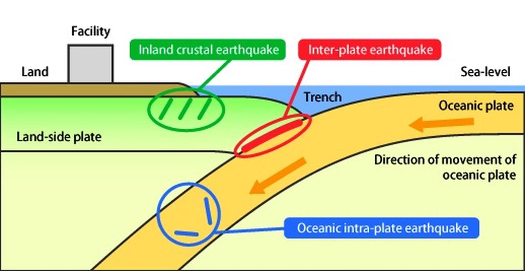
Illustration : The location of the epicenter of the earthquake in the south of Gunung Kidul (green color), the epicenter in the south of Sukabumi (blue color), and the epicenter of the earthquake that triggered the 2006 Pangandaran tsunami and 1994 Banyuwangi tsunami. Source: Daryono, BMKG
The Flores Sea earthquake with a potential tsunami hazard has sent us an important warning that an active source fault capable of generating a strong earthquake and triggering a tsunami had been missed on the mapping radar.
Beyond the Flores Sea, potentially destructive earthquakes that were triggered by active but unmapped faults have also occurred in the past. The Solok earthquake of 5.6 magnitude that struck on 28 Feb. 2019 damaged 343 houses and injured 48 people, appears to have been triggered by an unmapped, active inland fault.
The same holds true for the 6.5-magnitude Ambon earthquake that struck on 26 Sept. 2019 and left 31 people dead. The earthquake was followed by persistent aftershocks that reached more than 3,000 occurrences.
Another similar case was the 5.8-magnitude Tojo Una-Una earthquake on 26 Aug. 2021, which damaged several residential buildings and killed one person. The source of the earthquake had not been identified before then.
The identification of a "new" active fault in the Flores Sea can change the seismic hazard map of the area.
This new active fault adds to the number of sources of earthquakes and tsunamis in the Flores Sea and the surrounding area. This tectonic fact makes the Flores Sea one of the areas prone to earthquakes and tsunamis in Indonesia.
Tsunami-prone area
According to historical records, the source of the earthquake in the Flores Sea has generated large earthquakes and tsunamis several times.
Several tsunami events in East Nusa Tenggara, most of which had destructive impacts, occurred in 1818, 1820, 1836, 1855, 1896, 1897, 1927, 1961, 1982, 1989, 1991 and 1992. This proves that the Flores Sea is a tsunami-prone area.
The tsunami generated by the latest earthquake in the Flores Sea not only severed the province’s coastline, but also reverberated as far as South Sulawesi, as was also the case with the tsunami on 29 Dec. 1820. The strong earthquake with an epicenter below the Flores Sea triggered a deadly tsunami that hit not only the northern coast of Flores, but also South Sulawesi, where the death toll from the tsunami in Bulukumba was reportedly around 500 people.
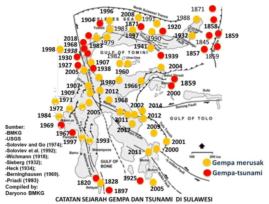
History of repeating earthquakes and tsunamis in Sulawesi and the Maluku Sea. The yellow dot indicates a destructive earthquake and red indicates a tsunami. Source: Daryono, BMKG, 2019
The tsunami that hit Alor Island on 18 April 1896, which was triggered by an earthquake originating in the Wetar thrust fault, killed 250 people.
The last destructive on 12 Dec. 1992 in the Flores Sea, triggered by a 7.8-magnitude earthquake, claimed 2,500 lives, largely killed by waves measuring over 30 meter high that swept inland. Some 500 people were unaccounted for. The tsunami also reached the coast of South Sulawesi, although it did not cause significant damage or casualties.
Mitigation efforts
The vulnerability of the Flores Sea to earthquakes and tsunamis means it is urgent to draw up appropriate mitigation measures with a view to realizing zero casualties from earthquake or tsunami events.
Tsunami mitigation as an anticipatory measure for the active fault in the Flores Sea needs to be modeled to determine the worst-case scenario.
This model is important for estimating a tsunami’s height and arrival time as a reference for mitigation. The model will also be useful for regional spatial planning based on tsunami hazards.
The building codes (for constructing structures) need to be implemented in order to minimize casualties from earthquakes.
Residents are advised to build houses with a strong, steel-reinforced structure. If this is not possible, build an attractively designed house that uses lightweight materials like wood and bamboo.
Also read:
Coastal areas need to be equipped with vertical evacuation buildings that are structurally resistant to earthquakes and tsunamis. It is necessary to construct an evacuation route equipped with sufficient signage.
In-transit evacuation structures need to be installed so that people can immediately reach safety in the event of an earthquake with tsunami potential. Mangrove forests, coastal firs, and palms must be preserved to slow tsunamis.
In order to instill a culture of earthquake and tsunami vigilance, it is necessary to intensify earthquake and tsunami mitigation through self-evacuation drills as well as training for the community, local officials and students. The mitigation program should also include strengthening disaster response teams by involving the public.
Community earthquake and tsunami vigilance must be supported with emergency response plans adapted to the worst-case scenario based on the latest earthquake and tsunami hazard assessment. An evacuation standard operating procedure (SOP) should be part of the emergency response plans.
By realizing all the mitigation measures above, we will be able to minimize the impacts of disasters so we can live safely and comfortably, even in disaster-prone areas.
It is important to conduct periodical evacuation or self-evacuation drills that follow the designated evacuation routes to reach in-transit refuges and shelters.
Local governments should continue to conduct community outreach activities on tsunami preparedness as part of the mitigation and emergency response for earthquakes with tsunami potential.
The BMKG will continue to improve its role in providing earthquake information and tsunami early warnings. The agency has prepared a tsunami inundation and hazard map and estimated tsunami arrival times modeled on the Flores Sea earthquake scenario.
To support the dissemination of earthquake information and tsunami early warning, the BMKG has installed more than 47 information and warning receivers across the BMKG’s integrated service centers, regional disaster mitigation agencies (BPBD), and Search and Rescue offices around the Flores Sea.
As part of disaster mitigation education, the BMKG will continue to organize activities through the Earthquake Field School (SLG) program. The SLG program provides understanding on earthquakes and tsunamis hazards, escaping them safely, and responding to early warnings.
Daryono.
It also aims to form a tsunami-aware community and tabletop exercises on following evacuation routes, installing evacuation signs and ensuring signage availability, recommending evacuation routes, and setting up evacuation transit points.
By realizing all the mitigation measures above, we will be able to minimize the impacts of disasters so we can live safely and comfortably, even in disaster-prone areas.
Earthquakes and tsunamis are ready to deploy in the underwater depths of the Flores Sea in particular and in Indonesia in general. What is important and imperative is to pursue concrete mitigation efforts, preparedness, and stakeholder and community capacity, as well as improving the existing infrastructure to deal with the threat of earthquakes and tsunamis.
Daryono, Earthquake and Tsunami Mitigation Coordinator, the Meteorology, Climatology and Geophysics Agency (BMKG)
This article was translated by Musthofid.