The flash flood that has claimed the lives of seven people in Batu, East Java, is a sign that vigilance is needed ahead of the rainy season. Other regions must not be complacent.
By
KOMPAS TEAM
·5 minutes read
KOMPAS/EMANUEL EDI SAPUTRA
Floods on the Melawi highway, Sintang city, Sintang district, West Kalimantan, Tuesday (2/11/2021). Until Sunday (7/11) the road was still flooded and even higher.
JAKARTA, KOMPAS – Floods, landslides and flash floods have hit a number of regions across the country as the rainy season arrives. Following the floods in Pidie (Aceh), Katingan (Central Kalimantan), Sintang (West Kalimantan), Luwu (South Sulawesi) and Bogor (West Java), a flash flood hit the cities of Batu and Malang in East Java, killing seven people.
As usual, the disasters were caused by heavy rainfall, land conversion and land use. Another factor is the La Niña phenomenon and the dynamics of local rainfall.
“At the beginning of November, it appears that La Niña’s strength may have become more moderate if we observe the decrease in temperature trends across the Pacific Ocean. In theory, these rapid changes cause the impacts to be felt more quickly,” said climate variability analysis coordinator Supari of the Meteorology, Climatology and Geophysics Agency (BMKG) in Jakarta on Saturday (6/11/2021).
The effects have included floods and landslides in a number of areas since the middle of the year. Flood survivors are still taking refuge in South Aceh, Aceh Singkil and Subulussalam. A total of 32 villages in the three districts were inundated by 30-100 centimeters of water.
In Central Kalimantan, flooding hit 11 regencies/cities and 23 subdistricts/villages to affect 12,006 families comprising 17,759 people since July.
In South Sulawesi, the flash flood that hit North Luwu in July last year have left survivors in temporary housing as they wait for construction of their permanent houses to finish. Last year’s disaster left 38 people dead and 10 people missing, with thousands of houses heavily damaged and submerged in sand and mud. Earlier this month, a number of villages were left deserted like kota mati (ghost towns).
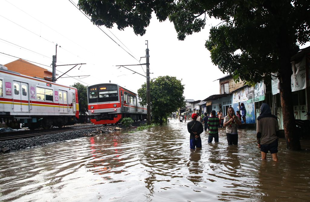
Kompas/Priyombodo
The commuter line train runs slowly as it passes through the Pesanggrahan area, South Jakarta, which was flooded due to heavy rains, Sunday (11/07/2021).
Impacts
According to the data from the National Disaster Mitigation Agency (BNPB) released on Sunday (7/11), 24,522 families comprising 87,496 people in Sintang regency, West Kalimantan, have been affected by flooding in 12 subdistricts as of Saturday. A total of 21,000 houses and five bridges were damaged.
Other regencies that lay in the path of the Kapuas River are still inundated, namely Melawi, Sekadau, Kapuas Hulu and Sanggau regencies. Sekadau Regional Disaster Mitigation Agency (BPBD) head Matthew Jon said that six local subdistricts and 26 villages were affected by floodwaters reaching 0.5-2.8 meters high. The flooding, which lasted 17 days and affected thousands of families, is Sintang’s worst recorded flood in decades.
Post-disaster cleanup and management are still being carried out in Batu. An aerial survey on Saturday showed that five landslides in an upstream area of the river caused a natural dam to burst. As a result, the flood carried mud, stone, tree debris and other materials found along the river, which increased the volume of the floodwater when it arrived at human settlements.
“The mountaintops are being cleared while the river valleys are turned into [housing areas] and used as garbage dumps,” said Amin Widodo, a disaster researcher at the 10 November Technology Institute (ITS) Research Center for Mitigation, Disaster and Climate Change in Surabaya.
BMKG climate researcher Siswanto said that the present trend involved relatively short durations of rainfall lasting 1-3 hours but at high intensities, influenced by an increase in local temperatures.
“Globally, a 1-degree Celsius increase in surface air temperatures increases the atmospheric water vapor by 7 percent. This is equivalent to 7 percent [greater] rain intensity. In our study in Jakarta, this increase [in rainfall intensity] could double to 14 percent,” he said.
Like Jakarta, the level of water vapor in the atmosphere was found to have doubled in Hong Kong as well, indicating a faster precipitation and water cycle.
Local rainfall dynamics across Indonesia are also influenced by the local topography, such as in Luwu, where flooding often occurs in the middle of the year when other areas are dry.
KOMPAS/DAHLIA IRAWATI
A joint team clears land that was once a flash flood in Batu City, East Java, Saturday (06/11/2021).
Siswanto added that although some areas saw an increase in rain and flooding, no area had recorded daily rainfall intensity reaching 100 millimeters.
“Including the rain that triggered the floods in Batu a few days ago, [rainfall] intensity has not been extreme. Rain is not the only causal factor for flooding, but also environmental management,” he said.
In relation to this issue, Batu Mayor Dewanti Rumpoko said the city administration would evaluate disaster-prone areas. People living along the river would be relocated. Plants with strong root systems would be planted on riverbanks to prevent erosion. The administration also planned to plant trees in upstream areas to minimize landslides.
Lingering Risks
The risk of weather anomalies and climate disasters remains as the rainy season intensifies alongside the La Niña phenomenon. “With [increased] rainfall, the potential for landslides also increases, especially in areas with steep slopes,” said Andiani, the head of the Energy and Mineral Resources Ministry’s Center for Volcanology and Geological Hazard Mitigation (CVGHM).
Every month, Andiani’s team maps ground movement hazard zones up to the subdistrict level and forecasts ground movement potential. Local administrations can then use this map by to anticipate disasters.
According to a study by Supari et al. (2008) published in Climate Dynamics, if La Niña strengthens in the September-November period, a general increase in rainfall occurs in the central and eastern regions of Indonesia, which covers most of Java, Bali, West Nusa Tenggara, East Nusa Tenggara, the eastern part of Kalimantan, Sulawesi, Maluku and North Maluku.
The risk of weather anomalies and climate disasters remains as the rainy season intensifies alongside the La Niña phenomenon.
Floods and landslides have occurred outside these regions, however. Vigilance is thus needed to minimize potentially fatal risks.
Climatology researcher Erma Yulihastin at the BRIN Atmospheric Science and Technology Research Center called on residents of Greater Jakarta to be aware of extreme rainfall in the early morning hours, such as those that occurred in 2020 and 2021 to trigger massive flooding. A study by Erma and her team, published on 4 Oct. 2021 in the Journal of the Meteorological Society of Japan (JMSJ), found that extreme rainfall in the early hours of the morning was closely related to northerly surface winds crossing the equator, which were typically very strong. (AIK/TAM/AIN/NIT/WER/NIK/GIO/IDO)