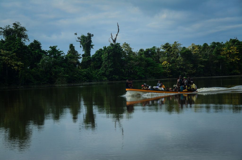
My heart was beating really fast as the sun began to shine and the boat entered the Fly River, which divides the two countries. To the left of the river is Indonesia, and PNG to the right.
By
AGUSTINUS WIBOWO
·5 minutes read
AGUSTINUS WIBOWO
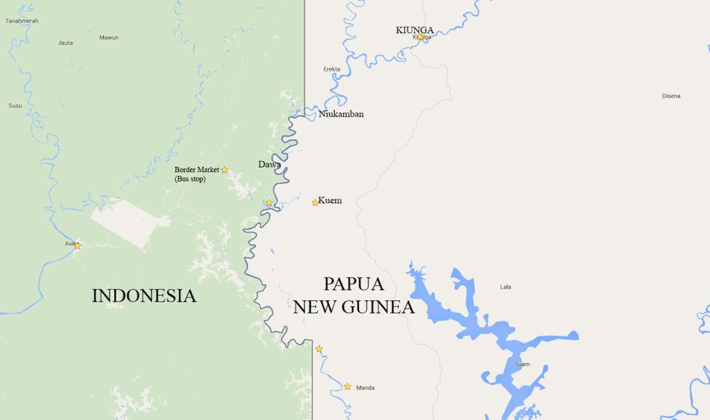
Map of the borders of Indonesia and Papua New Guinea. Location of international markets Indonesia-Papua New Guinea, as well as Kuem and Kiunga, Papua New Guinea
On the journey from Kuem to the town of Kiunga, I finally crossed the strangest area of the border between Indonesia and Papua New Guinea (PNG): the “swelling” of the Fly River.
I boarded the boat belonging to Raven, a middle-aged man from Kuem who was going to sell tilapia fish to Kiunga. We departed at 2 a.m.
My heart was beating really fast as the sun began to shine and the boat entered the Fly River, which divides the two countries. To the left of the river is Indonesia, and PNG to the right.
However, the international boundary line is a bit absurd. In reality, on the left and right of the river are the same wild forests, with towering trees reaching the same sky. There is no sign of anything serving as a marker of the country\'s borders.
This beautiful section of the river is actually dangerous to visit, especially for Indonesians. I started to tremble with fear as Raven pointed to the right side of the river, saying, “OPM [Free Papua Movement] camp!”
In the Fly River border area, there are a number of so-called OPM camps. What I could see were two or three wooden huts on stilts, with leaf roofs.
In the second “OPM camp,” Raven stopped the boat. This is Dawa, aka Yot, the largest Indonesian Papuan refugee camp along the Fly River. What is surprising is the fact that Dawa is on the left side of the river. This means that this "OPM camp" is actually located in Indonesian territory.
Our boat berthed, and Dawa appears as a small village with several huts on stilts.
"Guy," Raven called out in Indonesian. "Hurry up please!"
From the camp, a woman ran nimbly with a noken basket resting on her head. She climbed into the boat and sat on a jerry can of oil. She would ride with us to Kiunga.
AGUSTINUS WIBOWO
Trip from Kuem to Kiunga
This was the first time for me to meet an OPM refugee. But is such a small and cheerful woman really a part of the force that wants to fight against Jakarta\'s authority?
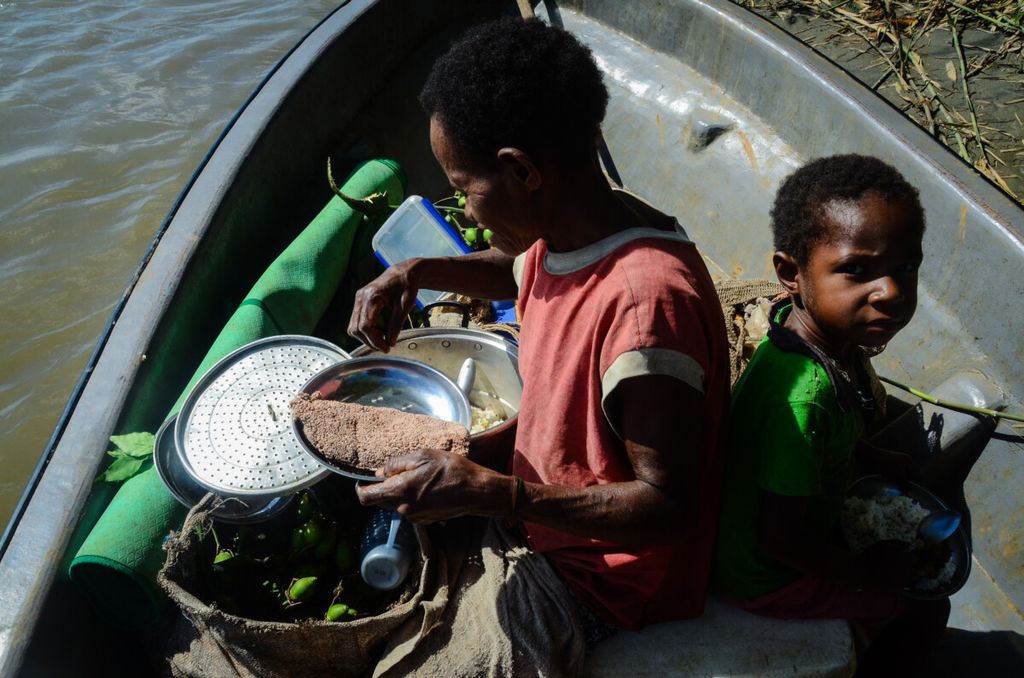
The noken basket she was carrying contained fresh green betel nuts. She wanted to sell them at the market in Kiunga for 80 toea to 1 kina (28 US cents) per piece. From a metal pot, she took out her lunch: rice, fried instant noodles and fried fish — similar to what Indonesians would eat.
The woman named Dome said that behind Dawa, there was already a road to Indonesia. The refugees also regularly went to Indonesia for shopping. The Javanese had even reached the forest behind Dawa to collect wood.
***
The sun was getting increasingly hot. Suddenly, our boat stopped in the middle of the river. Raven started the engine several times, but the engine wouldn\'t start either.
Bad news: We were out of gasoline. More bad news: We only had one oar. We were floating in the middle of the river. Kiunga was still 40 kilometers away.
Raven cold only row the boat with one oar. Of course the boat hardly moved and we were going against the current of the river. After two hours, we couldn\'t stand it anymore.
From the opposite direction, a long boat with two men passed by. Raven shouted in Malay, “Guys! Guys!” It seemed that Malay has become the main language, because of the presence of the OPM refugees from Indonesian Papua. The men agreed to give us a liter of gasoline in exchange for sago and a few betel nuts from Dome, plus some money from Raven.
AGUSTINUS WIBOWO
Dome (left), having lunch on the way to Kiunga.
Finally, we arrived at the nearest village. This village is called Niukamban, aka Katawin. It is also an alleged OPM camp. Raven got out of the boat, about to buy gasoline from the villagers. He advised me to be careful so as to prevent someone from knowing that I was Indonesian.
Therefore, to all the villagers I met, I introduced myself to be Chinese and only spoke English. Raven entered the village leader\'s house, asking for help to find gasoline.
I waited outside the house, observing the condition of the village. The village was very poor, almost everyone was barefoot and the majority of the children were undressed. The clothes worn by adults were already torn. Most of their clothes had the logos of Indonesian political parties on them.
A young man named Johnny claimed to be 15 years old, but the wrinkles on his face suggested he could be 40. He spoke Indonesian with me because it was the only language he could speak. Johnny admitted that he often crossed to Tunas village on the Indonesian side.
"My family is in the neighboring land, but I live here because this has become my homeland," he said.
He also had an Indonesian ID card, which made it easy for him to get in and out of Indonesia.
***
We had only arrived in Kiunga when the evening sun began to dim over the town. Kiunga is like a metropolis in the middle of the forest. From a distance, the modern harbor, big ships, iron towers and tall metal buildings could be seen. After weeks in the remote hinterland, I felt the beauty of modernity.
Raven accompanied me to a Protestant church where I was staying the night in Kiunga.
"Be ready for tomorrow. I will take you to meet the OPM leader," he said.