The local government has prepared evacuation sites after the danger level at the volatile Mount Merapi was raised. A total of 30 hamlets are in the danger zone.
By
Haris Firdaus/Nino Citra Anugrahanto/Regina Rukmorini
·4 minutes read
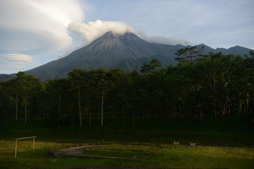
Kompas/Ferganata Indra Riatmoko
Mount Merapi seen from Glagaharjo Village, Cangkringan, Sleman, Yogyakarta Special Region, Thursday (5/11/2020) morning. The Geological Disaster Technology Research and Development Center (BPPTKG) raised the status of the mountain from Waspada ((the third-highest level) to Alert ( second-highest level) on that day starting at 12.00.
YOGYAKARTA, KOMPAS — After Mount Merapi\'s alert level was raised from Waspada (the third-highest level) to Siaga or the second-highest level on Thursday (5/11/2020) starting at noon, as many as 30 hamlets in Yogyakarta and Central Java were now in the danger zone. The hamlets that could be affected by the eruption are located within a 5 kilometer radius of the peak of Merapi.
Of the 30 hamlets, 3 hamlets are in the Cangkringan district, Sleman, Yogyakarta. The three hamlets are Kalitengah Lor hamlet, Kaliadem hamlet, and Pelemsari hamlet.
A total of 27 other hamlets are located in Central Java province, namely 9 hamlets in Magelang, 9 hamlets in Boyolali, and 9 hamlets in Klaten.
Related to this, yesterday, the local government up to the village level began preparing evacuation sites if residents in those hamlets had to evacuate at any time. "Everything is being prepared. If Merapi erupts, we are ready,” said Regional Secretary of Sleman regency Harda Kiswaya after visiting the evacuation barracks in Banjarsari hamlet, Glagaharjo village, Cangkringan district, Sleman, yesterday evening.
Harda explained that the evacuation barracks in Banjarsari hamlet could actually accommodate 400 people. However, during the Covid-19 pandemic, the capacity of the barracks was limited to a maximum of 150 people. The barracks are located beside the Glagaharjo village hall, 12 kilometers from the peak of Merapi.
The head of the Mitigation Section of the Regional Disaster Management Agency (BPBD) of Sleman, Joko Lelono, added that his party also checked community data in vulnerable areas. Evacuation barracks are also prepared.
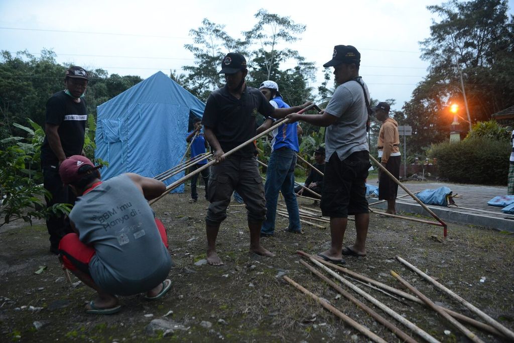
Kompas/Ferganata Indra Riatmoko
Residents worked together to build tents to accommodate refugees at the Bronggang State Elementary School complex, Argomulyo Village, Cangkringan, Sleman, DI Yogyakarta, Thursday (5/11/2020). The refugee camp was prepared as a temporary shelter for refugees who were not accommodated in the refugee barracks at Glagaharjo Village.
Due to the Covid-19 pandemic, a number of adjustments are made in the refugee barracks. For example, in line with the implementation of physical distancing, a partition in the evacuation barracks is made, and each plot will be occupied by one household.
The availability of masks has also been checked. Currently, there are 90,000 masks from BPBD Sleman and BPBD Yogyakarta.
The Magelang regency administration has begun preparing a final evacuation site for evacuees from hamlets in the danger zone of Merapi. The head of BPBD Magelang, Edy Susanto, said that his party is trying to make the final evacuation site be able to be used immediately. "If the final evacuation site is ready with all the supporting facilities, today the evacuation of the evacuees will be carried out immediately," he said.
Meanwhile, the head of Dukun district, Magelang, Amin Sudrajad, said he had asked the village governments, specifically Paten village, to prepare its residents to evacuate. The preparation is particularly intended for vulnerable groups, namely the elderly, pregnant women, sick people, and children.
Two of the nine hamlets in Magelang that are in the danger zone are Babadan I and Babadan II hamlets in the Dukun district.
Siaga status
The potential danger from the eruption of Mount Merapi, as of yesterday, was estimated to be within a maximum radius of 5 kilometers from the peak of Merapi.
Since 21 May 2018, the alert status of Mount Merapi has been on Siaga level or the third highest level. The radius of danger from the eruption was set as 3 kilometers from the peak.
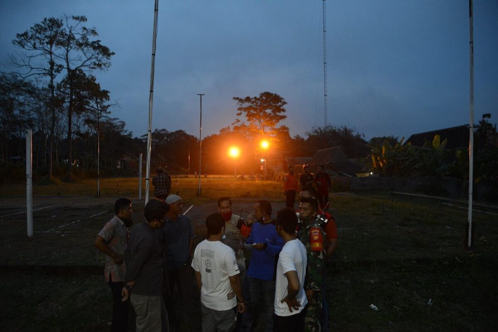
Kompas/Ferganata Indra Riatmoko
Volunteers inspect the location for the evacuation barracks which are being prepared at the Glagaharjo Village office, Cangkringan, Sleman, DI Yogyakarta, Thursday (5/11/2020).
The determination of the status of the mount on the border between Central Java and Yogyakarta was carried out by the Geological Disaster Technology Research and Development Center (BPPTKG), a government agency that monitors the volcanic activity of Merapi.
In a letter dated 5 November 2020 that was made available to a number of parties, the head of BPPTKG, Hanik Humaida, said that the current volcanic activities of Merapi could continue until the eruption. Potential dangers are in the form of lava avalanches, discharge of volcanic materials, and hot clouds up to a maximum distance of 5 kilometers.
Besides announcing the list of hamlets that could be affected by the eruption, BPPTKG also asked mining activities in the river channels that originate in the Disaster Prone Area III of Mount Merapi to stop. The same was recommended for tourism. "Climbing activities in Merapi are also still not allowed," he said.
The increase in the danger status of Merapi cannot be separated from the increase in the intensity of the earthquakes and the rate of deformation of Merapi. After the eruption on 21 June 2020, said Hanik, the internal seismic activities in Merapi, namely deep volcanic earthquakes, shallow volcanic earthquakes, and multi-phase earthquakes, began to increase.
Until now, seismicity and deformation are still increasing.
Starting October, seismic activity in Merapi has intensified. At present, its activities have exceeded the condition ahead of the appearance of the lava dome on 26 April 2006 or ahead of the eruption that year. However, current activities are still lower than the 2010 eruption.
"Until now, seismicity and deformation are still increasing. Based on that, a quick magma extrusion process or an explosive eruption will possibly happen," he said.