On Friday there were two earthquakes, namely in South Buton, Southeast Sulawesi; and Aceh Singkil, Aceh province. Two shallow earthquakes centered tens of kilometers from land amplified risk signals in coastal areas.
By
Saiful Rijal Yunus
·4 minutes read
Kompas
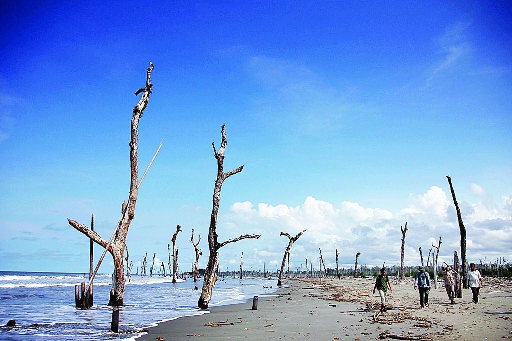
Dead trees on the edge of Singkil Lama beach, Aceh, on Saturday (25/2/2012). Hundreds of years ago, the area was a dense forest. The forest then sank due to rising sea water inland due to the earthquake and tsunami.
On Friday there were two earthquakes, namely in South Buton, Southeast Sulawesi; and Aceh Singkil, Aceh province. Two shallow earthquakes centered tens of kilometers from land amplified risk signals in coastal areas.
KENDARI, KOMPAS — An earthquake with a magnitude of 5.4 rocked the South Buton region on Friday (9/10/2020). People were advised not to panic, but to remain vigilant.
Aceh Singkil was also rocked by an earthquake with a magnitude of 4.5 at 12:57 p.m. The epicenter was at sea at a depth of 27 kilometers, 29 kilometers southwest of Aceh Singkil regency.
The shock of the earthquake in South Buton on Friday was felt in Baubau. Objects shook.
"It was terribly felt, but briefly, a few seconds. I thought there was a truck passing, it turned out to be an earthquake,” said Salman, a resident of Baubau, Southeast Sulawesi, yesterday.
A number of residents panicked. They rushed out of their houses and were on guard, fearing that there would be aftershocks or a tsunami. After a while, a warning from the Meteorology, Climatology and Geophysics Agency (BMKG) said that this earthquake would not be accompanied by a tsunami.
It was not only felt in Baubau but also on Kabaena Island, Bombana. The residents felt a strong shock for about two seconds. Based on BMKG data, the earthquake epicenter was there at sea, 47 kilometers southwest of South Buton. The earthquake was classified as shallow at a depth of 10 kilometers.
On 18 August 2020 at 10:00 am, movement in the Buton Fault also triggered an earthquake with a magnitude of 4.6 in the North Buton region. The earthquake in August was also classified as a shallow earthquake.
The head of the Kendari Geophysics Station, Rosa Amalia, explained that the earthquake on Friday morning was one of the quite larger earthquakes in the Buton Fault in 2020. However, the earthquake did not have the potential to cause a tsunami.
"We have not received a report on the damages. There were only shocks up to MM III in South Buton and MM II in Buton,” said Rosa, referring to the Modified Mercalli Intensity Scale.
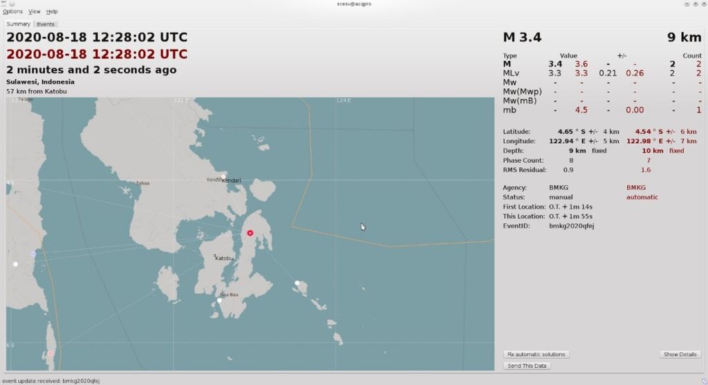
DOKUMENTASI STASIUN GEOFISIKA KENDARI
Map of Buton region, Southeast Sulawesi.
The earthquake that occurred on Friday, according to her, was a type of shallow earthquake caused by the Buton Fault activity. An analysis of the source mechanism showed that this earthquake had a thrust fault mechanism. The earthquake occurred in segment B of the Buton Fault.
Active fault
The Buton Fault is among active faults in Southeast Sulawesi. This fault moves 0.1 millimeters per year with two segments, namely segment A along 60 kilometers on Muna Island and segment B along 29 kilometers on Buton Island.
"Two aftershocks were recorded with magnitudes of 4.1 and 3.5, respectively. The earthquakes were in the same location with a depth of 10 kilometers and 35 kilometers,” she said.
Since early July, Rosa further said, her party had recorded an increase in activity in the fault. In total there were seven earthquakes in July, six of which were felt by the community. The Buton Fault is a local fault on the mainland of the two islands.
However, people were asked to remain calm and to not be affected by information from unclear sources. The community was also advised to remain prepared by understanding basic mitigation.
In Southeast Sulawesi there are a number of active faults, including Buton Fault, Naik-Tolo Fault, Kendari Fault, Tolo Fault and Lawanopo Fault. The Buton Fault is quite active, as marked by earthquake shocks for several times.
In 2013, an earthquake with the magnitude of 4.6 rocked Buton and damaged around 300 houses, and forced thousands of residents to evacuate. The impact of the earthquake was most severely felt in Batauga district, the epicenter of the earthquake. The first earthquake occurred at 5:22 p.m. on one day. As of the afternoon on the next day, dozens of aftershocks with lower intensity were felt by the residents.
In August 2020, earthquakes rocked three times a day in North Buton. However, there were no reports about the residents who were evacuated.
Buildings, houses of the residents, and infrastructure must be given an attention.
The high threat of earthquakes in the islands region makes coastal areas prone to geological disasters. Buildings, houses of the residents, and infrastructure must be given an attention.
Barbara Neumann\'s research in the journal PLOS One (2015) mentioned that Indonesia is one of five countries in Asia with the largest population living in coastal areas that are prone to natural disasters, either by rising sea levels due to climate change, flooding, or the tsunami.
The risk of disasters is increasing due to the growth of cities towards the coastal areas. Moreover, in the last five years, the government has prioritized the development of infrastructure on the coast in order to support the sea highway and the development of coastal areas (Kompas, 21/11/2019).