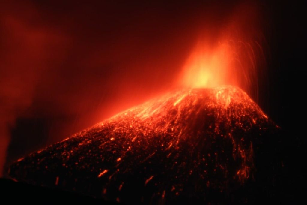
Gunung Anak Krakatau was photographed by the Coordinator of Activities of the Jakarta Amateur Astronomy Association Muhammad Rayhan, from the Bahari Club Lodge, Anyer, Banten, Saturday (12/22/2018) around 7:00 p.m. to 7:30 p.m. WIB. Then at 21.03 WIB a landslide slope of Anak Krakatau which allegedly triggered a tsunami on the west coast of Banten and south of Lampung.
The tsunami that hit Banten and Lampung on Saturday claimed 429 lives, while 154 people are still missing. This was far from being the worst disaster to hit the region. The eruption of Mount Krakatau 135 years ago triggered a 20-meter high tsunami that killed 36,417 people.
The volcanic eruption in the Sunda Strait on Aug. 27, 1883, was a level 6 based on the Volcanic Explosivity Index (VEI). Mt. Tambora’s 1815 eruption was a level 7 and super volcano Toba’s eruption in North Sumatra 74,000 years ago was a level 8.
The 1883 Krakatau eruption was 21,574 times more powerful than the atom bomb that was dropped on Hiroshima (De Neve, 1984). Apart from destroying Krakatau Island, the eruption laid waste to all life on the shores of Banten and Lampung. Its horrors were portrayed in local poems, such as in Muhammad Saleh’s Syair Lampung Karam (Poem on Wrecked Lampung), as well as in colonial records.
After the eruption that destroyed the volcano, Mt. Anak Krakatau (Child of Krakatau) emerged on Dec. 29, 1927. Since then, the new volcano has been growing at a significant rate. Mt. Anak Krakatau covered 156.75 hectares and was 201.5 meters above sea level in 1983 (Suhadi 2004). The Center for Volcanology and Geological Hazard Mitigation (CVGHM) in September this year found that the mountain had grown to 338 m above sea level.
This is linked to the area’s geological activities. Mt. Anak Krakatau lies in a subduction zone between the Indo-Australian and the Asian tectonic plates. Anak Krakatau has 93 percent intrusive growth and 7 percent extrusive growth (Wohletz and Heiken, 1972).
Intrusive growth reflects the volume of magma that penetrates the earth’s crust and forms intrusive igneous rocks below the volcano. Extrusive growth, on the other hand, is the explosive eruption of magma on the earth’s surface that results in pyroclastic material and lava flow that form the conic body of unstable young mountains.
As Anak Krakatau grows, so do the human population on the shores of Banten and Lampung. The regions have also become strategic industrial and tourism hubs. Kompas research and development division data, based on 2018 Banten and Lampung regional statistics, shows that Pandeglang is home to 1.2 million people, Serang has 1.49 million and a number of tsunami-affected regions in Lampung has 2 million.
In the area, there are also 35 chemical processing factories. Consequently, a volcanic eruption or a tsunami can lead to a chemical explosion. A study by Fatma Lestari and team (2018) highlights the potential of catastrophic disaster in the Cilegon industrial zone if disaster risks are not managed properly. Disaster threats on the shores of the strait are not only linked to Krakatau. The 2017 National Earthquake Source Map shows that a potential 8.7-magnitude earthquake lurks in the strait.
A study by Yudhicara and K. Budiono in 2008 found records of historical tsunamis in the strait from various sources. Of the 19 tsunamis studied by Soloviev and Go (1974), three were caused by the eruption Krakatau or Anak Krakatau -- in 416, 1883 and 1928. Earthquake-linked tsunamis, on the other hand, occurred in 1722, 1852 and 1958. “The tsunami from the partial collapse of Mt. Anak Krakatau was not the worst. This is merely an early warning,” said Indonesian Tsunami Experts Association chairperson Gegar Prasetya.
Early warning
Technically, tsunamis in the strait can be anticipated. However, the Indonesian Tsunami Early Warning System (Ina-TEWS) was designed to anticipate tsunamis triggered by earthquakes instead of by volcanic eruptions or underwater landslides. Bandung Institute of Technology tsunami expert Hamzah Latief said tsunamis from Krakatau’s volcanic activities could be detected early on. “It is easier to detect than earthquakes as the location of the source of danger is obvious. The difficult thing to do is to coordinate between agencies.”
Equipment to monitor changes in sea surface levels has been installed on islands around Anak Krakatau, such as Sertung and Rakata. However, this is just one component of disaster risk mitigation. Gegar said the most important thing to do was to evaluate spatial planning in danger zones and locals’ preparedness.
The fact is that the Ina-TEWS, since it was established in 2008, has yet to prove its effectiveness in saving lives, including the recent tsunami in Palu Bay. Depending exclusively on early warning systems for safety in disasters only leads to a false sense of security. Preparedness, including knowledge of independent evacuation during Anak Krakatau’s eruption, is necessary.
We seem to have neglected the warnings of Anak Krakatau. This reminds us about the conditions prior to the 1883 eruption. “Some people at the time deemed Krakatau long been dead and would not pose any danger,” Simon Winchester wrote in 2003.
History has repeated itself. Before the tsunami, most people saw Anak Krakatau as merely an entertaining display and its enflamed rocks nothing more than fireworks. A history of destruction is buried deep in people’s psyche (AHMAD ARIF)