The night before, a smuggler almost succeeded in entering the marine region that is protected under the village’s customary laws.
By
ICHWAN SUSANTO, M FINAL DAENG, INGKI RINALDI
·6 minutes read
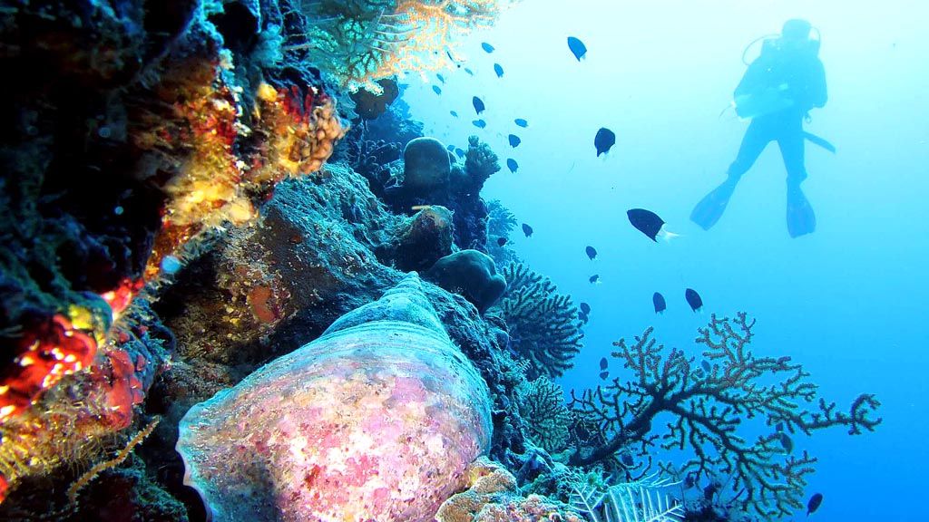
Kompas/Ichwan Susanto
A diver floats along a coral shelf in the waters of Wali village Kaombo, Binongko island, Wakatobi, in the Sept. 26 file photograph. Since 2015, the people of Wali village have closed their waters from overfishing and other exploitative marine activities. The kaombo protected area can help restore the condition of the local ecosystem, which had been damaged by fish bombing.
Lakona, 72, swiftly rowed his boat towards shore. He has lived on the beach for a month to protect the kaombo waters off Wali village in Binongko district, Wakatobi, Southeast Sulawesi.
Approaching the rocky beach, Lakona approached Jaenuddin, 52, and spoke in the local tongue. He told Jaenuddin that they would need more buoys to mark the kaombo boundary. He also reminded Jaenuddin that it was important that the kaombo information board faced outward, to the sea.
The night before, a smuggler almost succeeded in entering the marine region that is protected under the village’s customary laws. Fishermen from outside the village use the lack of signage and a proper boundary as an excuse to enter the protected waters.
Former Wali village head Jaenuddin, who had initiated the kaombo law’s reenactment, nodded. He agreed with Lakona and promised to fulfill his requests.
After voicing his concerns, Lakona went back to his boat and rowed it to the other side of the promontory. Lakona is a volunteer who helps protects the local seas protected by the village’s customary laws. He has helped enforce the kaombo customary law since February 2015. Kaombo restricts people from taking land and marine resources that do not belong to them. Violating kaombo means punishment.
On the seas, kaombo is implemented by closing certain regions to fishing activities. Even dropping anchor is prohibited. The goal is to recover these regions from further damage and ensure that their resources are sustained.
A Kompas team participated in a monitoring dive on Sept. 25-27 alongside representatives from environmental group World Wide Fund for Nature (WWF) Indonesia, the Wakatobi National Park management office, and local villages. The dive was made after obtaining permission from the local customary institution, Sarano Wali. The kaombo was on the southeastern end of the Wakatobi islands, at the tip of Binongko Island between the Banda and Flores seas.
Recovering
Apart from visiting the kaombo area, the team also measured the coral cover and abundance of fish within the tourism zone of the surrounding seas, including off Yorro Beach and in Mercusuar Cape, as well as in the local usage zone. The data from these locations were compared with the results from the kaombo area. The data was to be used as a baseline in future coral cover and fish abundance monitoring.
The resulting data showed that the local coral cover was in good condition. Coral cover in the tourism zone, at 74 percent, was a little better than the 72 percent in the kaombo area.
The bad news was that coral bleaching was found in certain parts of the kaombo area. Meanwhile, the good news was that the kaombo area had a higher biomass of commercial fishes, although not by much.
WWF Indonesia’s Wakatobi monitoring team head, Kartika Cendrakasih Sumolang, said that signs of past bomb fishing were still visible in the kaombo area. Upon hearing this, Jaenuddin stood in silence, awash with his memories of witnessing environmentally destructive fishing activities.
Another good news was that juvenile corals were emerging in the kaombo area, a sign that the marine ecosystem was recovering. Environmental protection under customary laws can be a turning point for coral recovery.
This is why the idea of reenacting the kaombo law is highly beneficial. WWF Indonesia records show that kaombo was still implemented in Wali prior to 1950. The kaombo protection covered forests, mangrove areas and beaches. Old agreements were still in place and were recorded in a local document called Kasawa Culada Tapetape (verbal records) through 1960. Public punishment was handed down to violators.
Between 1960 and 2007, the lakina system, or the Sarano Wali leadership, slowly disappeared as a result of the nationwide implementation of the village administration system. The kaombo system was reinstated between 2008 and 2013 with support from the Coremap II program, implemented in collaboration with the Maritime Affairs and Fisheries Ministry and the Indonesian Institute of Sciences’ oceanography research center.
Feb. 15, 2015 marked the reenactment of the kaombo marine law with the installation of a simple border around the waters. The border was installed on the northern and southern sides or the designated area, as well as along the natural border between the coral reef and the deep sea.
To the south, the border was placed along Wengkawengka beach of Haka village. The northern border demarcates the kaombo area at Selo Beach.
In its inaugural estimated measurement, the kaombo region was determined to be 600 meters wide along the shoreline and 300 meters out to sea. In a recent measurement using global positioning system (GPS) devices, the total area was found to be 1,000 meters by 200 meters, or 2 hectares.
The kaombo area and its opening and closing times can be adjusted in line with customary agreements. The local people generally want the kaombo to be permanent. In terms of punishment, the people believe that those who violate the moropu-mosoka (total destruction) customary pledge will not survive.
La Ode Armin, the Imam Wali (one of Sarano Wali’s three leaders), said that customary sanctions reinforce those stipulated under formal laws. “People can play around with the state laws, but not with the customary laws,” he said.
La Ode Hasahu, the Lakina Wali, said kaombo was a logical effort on the part of the Binongko people, especially those in Wali, to support life. The island, which borders the Banda and Flores seas, needs a sustainable population of coral fishes as the people’s source of protein. The people realize that only a healthy habitat (coral reefs) would sustain an abundant fish population.
The importance of coral reefs for Wakatobi is highlighted in the Maritime Affairs and Fisheries Ministry’s Journal of Maritime Affairs and Fisheries Socioeconomic Research (Vol. 11, No. 26, 2016). A research paper titled “The Economic Value of Wakatobi Regency’s Coral Reef Ecosystem” mentions that the indirect annual value of coral reefs as a natural tidal barrier is Rp 18.7 million (US$1,383.8) per hectare and its annual economic value as a fish breeding ground is Rp 7.3 million per hectare.
The estimated direct benefits of the area as a capture fishery is Rp 6.8 million per hectare per year, and the economic value of a seaweed cultivation is Rp 15.39 million per hectare per year.
For the people of Wali, the coral reef is even more valuable. The area is affected by the western and eastern monsoons, making it difficult to fish far from Binongko beach. Coral fishing is a safer choice to meet their daily protein needs.
Reenacting kaombo for the Wali people is more than mere nostalgia. For them, it is a communal effort to reinforce their maritime sovereignty and enforce marine conservation for their own welfare.