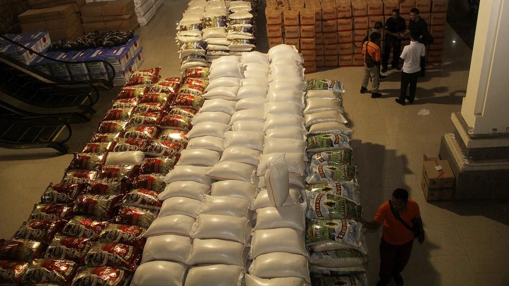
Stockpiles of aid fill the Mount Agung Disaster Mitigation Command Post at Tanah Ampo, Karangasem regency, Bali, Wednesday (27/9) night. Various kinds of aid continue to arrive at the command post as more residents evacuate to avoid the dangers of a possible Mount Agung eruption.
KARANGASEM, KOMPAS – Mount Agung in Bali’s Karangasem regency has entered a critical phase of volcanic activity, marked by strong and continuous shallow tremors. These tremors signify magma movement. Pilots are urged to be cautious when flying near the mountain.
Although it has yet to eject volcanic ash, a 500-meter-tall smoke column was seen rising from the volcano. At the Mt. Agung Observation Post in Rendang district, Karangasem regency, on Wednesday (27/9/2017), volcanic disaster mitigation head Gede Suantika of the Volcanology and Geological Hazard Mitigation Center (PVMBG) said that volcanic ash might erupt from the crater at any moment.
“Volcanic ash has very small particles and can easily be sucked up by airplane engines. The hot ash can melt and cover the airplane’s turbines. This endangers all airplanes that fly through the area. This information and warning is important because the possibility of a volcanic ash eruption,” Gede said.
The PVMBG has recommended airlines to stay away from Mt. Agung and not to fly near the area. The warning is especially important considering the increasingly active magma movement from inside the volcano since its alert level was raised to the highest Awas (Warning) status on Friday (22/9).
Mt. Agung’s Volcano Observatory Notice for Aviation (VONA) level has been raised from yellow to orange.
The change in color code was reinforced by an earthquake felt throughout Bali on Tuesday (26/9) afternoon that measured 4.2 on the Richter scale at a depth of 5 kilometers.
Gede said VONA indicates aviation-specific safety levels related to the amount of volcanic ash in the atmosphere, especially around volcanoes with Warning statuses. There are four color-coded levels in VONA: green, yellow, orange and red.
A code green means no volcanic activities, while yellow indicates the presence of volcanic activities. Orange means a high potential for eruption. Meanwhile, red is the highest level and indicates a volcanic eruption or that an eruption is imminent.
The height of the smoke column is expected to reach between 5 kilometers and 10 kilometers if an eruption occurs. However, no prediction has been made regarding the radius of the volcanic ash fall. This is because the spread of eruption material is highly dependent on wind direction and strength. “Currently, on Wednesday (27/9), the wind is moving to the southwest,” he said.
PVMBG chair Kasbani said that the VONA level increase does not mean a flight ban, but as a recommendation for flights passing in the area of Mt. Agung to be on high alert.
The government has arranged a plan to divert flights from Bali’s Ngurah Rai International Airport if its closure becomes necessary. Alternative airports include those in Banyuwangi, Surabaya and Lombok. Sea routes are also being optimized to smooth transport from and to Bali.
State-owned ferry company PT ASDP’s Ketapang-Gilimanuk branch has opened a post in Gilimanuk to accommodate evacuees from Bali departing to Java.
PT ASDP Ketapang-Gilimanuk general manager Elvi Josa said that 50 vessels had been prepared to provide ferry services from Bali to Java if mass evacuation was necessary.
Increased evacuees
Up to Wednesday night, Balinese residents were still fleeing their homes for the safety of temporary shelters. Up to 96,086 individuals had fled to 430 shelters in nine Bali cities/regencies.
The figure exceeded Karangasem regency’s estimate of 64,000 evacuees from its 200,000 population.
“There are 24 villages with 64,000 residents within a radius of 9 kilometers, including a sectoral expansion of 12 kilometers, around the mountain. This was why we expected this number of evacuees,” Karangasem Deputy Regent I Wayan Artha Dipa said.
However, outside this area, a large number of people who were worried about being affected by the Mt. Agung eruption had also evacuated their homes.
Aid packages continued to arrive through Wednesday, including 42.5 tons of rice, 200 boxes of instant noodle packets and 5,000 liters of cooking oil from the Chinese government. The Indonesian government has also set aside 269,000 tons of rice for the evacuees.
“For the rice, the government has more than enough stock. What we need now is a map of shelters because of the rapid growth in the number of evacuees,” Social Affairs Minister Khofifah Indar Parawansa said during a visit to an evacuation shelter in Tista village, Abang district, Karangasem, on Wednesday.
Separately, the West Nusa Tenggara (NTB) administration has opened its schools to all Balinese children who arrived in the province with their parents to seek shelter. The facilitation was to ensure that the children’s education would not be disrupted by Mt. Agung’s magmatic activity.
“The NTB provincial administration is ready to facilitate school-aged children to study at all schools on Lombok,” NTB Culture And Education Agency head Suruji said. Forty Balinese families currently are taking refuge in Lombok.