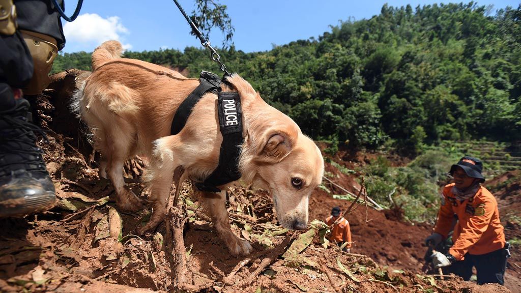
A dog is used to help search for victims of a landslide in Kepel village, Ngetos district, Nganjuk regency, East Java, on Tuesday (11/4). Five people were declared missing in the landslide, which took place on Sunday.
PONOROGO, KOMPAS — Some cracks in the ground on Mount Wilis in East Java still pose threats to residents living on its slopes, mainly in the regencies of Ponorogo, Kediri and Nganjuk.
There is a crack 90 meters long and 40 meters wide in the ground in Talun village, Ngebel district, Ponorogo. The crack caused the land to drop four meters.
“Thirty-nine families take refuge to prevent fatalities any time a landslide hits the area,” said the head of the Ponorogo Regional Disaster Mitigation Agency (BPBD), Budi Setiyono, on Tuesday (11/4).
A crack was also found on the other side, in Surat village, Mojo district, Kediri. Several cracks were found after the landslide last Thursday. Forty-one people were still taking refuge. BPBD Kediri\'s acting head, Randy Agatha, said locals had filled in some of the cracks in the ground.
Meanwhile, the threat of a landslide on a hill in Dayakan village, Badegan district, Ponorogo, had increased. BPBD Ponorogo\'s acting head, Sumani, said the region declared an Alert II status last Saturday. The number of residents being relocated increased from 293 to 341 people, consisting of residents of Watuagung and Kliur hamlets.
The Dayakan village head said residents were getting terrified. On Monday (10/4) locals heard sounds of landslides 20 times. The ground crack spanned more than 300 meters with a width of 40 centimeters and a depth of 3 meters. Twenty-two buildings, such as a school, a mosque, a health clinic and houses, were damaged.
The Geology Agency Center for Volcanology and Geological Disaster Mitigation (PVMBG) found the ground started to move in Watuagung village, Ponorogo, on March 2, 2017. The cracks were seen in the slope, on the village road and on rice fields and other cultivated land. “It is recommended that locals take refuge. This area could potentially experience landslides in the rainy session,” Geology Agency head Ego Syahrial said.
According to the PVMBG, several factors that caused the likelihood of ground movement in Dayakan included the thick yet soft soil and a rock base saturated with water. Besides, the slope was extremely steep. The area also had the Dayakan fault.
Separately, National Disaster Mitigation Agency spokesman Sutopo Purwo Nugroho said the search for 24 missing people buried in a landslide in Banaran village, Pulung district, Ponorogo was stopped following a subsequent landslide on Sunday. “Of the 28 victims, four people were found. Three hundred people still took refuge. Many of them will be relocated,” Sutopo said.
Heavy equipment difficult to enter
By the second day of the evacuation of Kepel village, Ngetos district, Nganjuk, the joint SAR team was unable to recover the five people buried in the landslide. The search was made by spraying water through a 3-inch hose into the pile of mud.
Two excavators that were to be brought to the site could not reach the location because the cliff was extremely steep (70 degrees) and was full of plants, rocks and trees. One excavator was blocked on the side of a 300-meter cliff. It would take two days to open access and bring the excavator down the river.
To reach the site, the team members had to carry all their tools down the trail. Previously, a SAR team created an emergency path using a wooden ladder to anticipate another landslide.
The joint SAR of 60 people was divided into groups, which alternately carried out the evacuation. Two sniffer dogs from the East Java SAR Agency canine squad were deployed.
SAR mission coordinator Lt. Col. Sri Rusyono said the evacuation was carried out manually while awaiting the heavy equipment.
Energy and Mineral Resources Ministry PVMBG main engineer Eddy Mulyadi Soepardi at the landslide post in Kepel village said there were some possible causes of the landslide in Kepel. Aside from the intense rain, the steepness of the 60- to 70-degree cliff made it prone to landslides.
“The rock is old. It is not young volcanic rock, so the soil erodes easily. This structure is not only found on Mt. Wilis, but also on other mountains,” he said.
A Kompas observation found the landslide area was under cultivation, planted with cassava, soy and peanuts. Meanwhile, the soil on the edge of the cliff was planted with mango, cloves, durian and teak.
Flash flood in Aceh
A flash flood struck Batu 200 village, Lawe Sigala-gala district, Southeast Aceh, on Tuesday at about 6 p.m. Consequently, the Southeast Aceh and Medan in North Sumatra was cut off because the road was blocked by a landslide spanning 15 meters.
BPBD Southeast Aceh emergency and logistics head Irwan said the flash flood hit the Batu 200 River because of piles of wood and logs that were stuck under a bridge, blocking the river water.
When the river swelled and the current grew powerful, the blockage was broken and the water and debris overflowed onto the road and into the residential area. By 9 p.m. there were no reports of casualties in the disaster.